 Bel-Ha
San Jose El Alto
El Porvenir
Nueva Palestina
Santa Lucía
Chemax
La Morita
Temoac
Zacualpan
Bel-Ha
San Jose El Alto
El Porvenir
Nueva Palestina
Santa Lucía
Chemax
La Morita
Temoac
Zacualpan
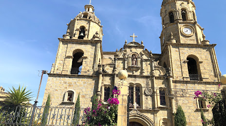
Parroquia Santa Rosa de Lima on the map, Muzquiz, Mexico
Photo
Where is located Parroquia Santa Rosa de Lima
Parroquia Santa Rosa de Lima — local attraction, which is located at Sta. Rosa, Zona Centro, 26340 Santa Rosa de Múzquiz, Coah., Mexico and belongs to the category — catholic church. Average visitor rating for this place — 4.8 (according to 146 ratings, information from open sources and relevant for 2022).
Exact location — Parroquia Santa Rosa de Lima, marked on the map with a red marker.
You can get directions to Parroquia Santa Rosa de Lima on the map from your location.
What else is interesting in Muzquiz? You can see all the sights if you go to the city page.
Coordinates
Parroquia Santa Rosa de Lima, Mexico coordinates in decimal format: latitude — 27.87741794840244, longitude — -101.51379802760665. When converted to degrees, minutes, seconds Parroquia Santa Rosa de Lima has the following coordinates: 27°52′38.7 north latitude and -101°30′49.67 east longitude.
Nearby cities
The largest cities that are located nearby:
- Monclova — 107 km
- Piedras Negras — 133 km
- Ciudad Acuna — 169 km
- Nuevo Laredo — 198 km
- Laredo
 (United States) — 203 km
 - General Escobedo — 261 km
- San Nicolas de los Garza — 265 km
- Santa Catarina — 266 km
- Apodaca — 267 km
- San Pedro Garza García — 269 km
- Monterrey — 270 km
- Guadalupe — 273 km
- Saltillo — 276 km
- Matamoros — 311 km
- Torreón — 319 km
- Gómez Palacio — 320 km
- San Antonio (United States) — 338 km
- McAllen (United States) — 375 km
- Reynosa — 377 km
Distance to the capital
Distance to the capital (Mexico City) is about — 970 km.