
 Belém
Maranguape
Paranaguá
Paranaguá
Monte Alegre
Alvorada de Minas
Bragança
Laguna
Ibiporã
Belém
Maranguape
Paranaguá
Paranaguá
Monte Alegre
Alvorada de Minas
Bragança
Laguna
Ibiporã
Fundação Projeto Tamar - Ubatuba on the map, Ubatuba, Brazil
Photo
Where is located Fundação Projeto Tamar - Ubatuba
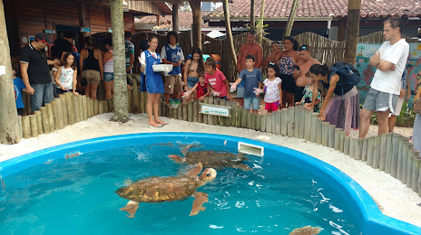
Fundação Projeto Tamar - Ubatuba — local attraction, which is located at R. Antônio Atanázio, 273 - Itaguá, Ubatuba - SP, 11680-000, Brazil and belongs to the category — animal protection organization. Average visitor rating for this place — 4.7 (according to 11304 ratings, information from open sources and relevant for 2022).
Exact location — Fundação Projeto Tamar - Ubatuba, marked on the map with a red marker.
You can get directions to Fundação Projeto Tamar - Ubatuba on the map from your location.
What else is interesting in Ubatuba? You can see all the sights if you go to the city page.
Coordinates
Fundação Projeto Tamar - Ubatuba, Brazil coordinates in decimal format: latitude — -23.452319176191587, longitude — -45.070464875474876. When converted to degrees, minutes, seconds Fundação Projeto Tamar - Ubatuba has the following coordinates: -23°27′8.35 north latitude and -45°4′13.67 east longitude.
Nearby cities
The largest cities that are located nearby:
- Taubaté — 66 km
- Pindamonhangaba — 68 km
- Guaratinguetá — 70 km
- São José dos Campos — 86 km
- Jacareí — 91 km
- Angra dos Reis — 91 km
- Mogi das Cruzes — 112 km
- Resende — 125 km
- Suzano — 125 km
- Itaquaquecetuba — 128 km
- Poá — 129 km
- Guarujá — 134 km
- Barra Mansa — 135 km
- Ribeirão Pires — 137 km
- Santos — 139 km
- Mauá — 142 km
- Volta Redonda — 144 km
- Cubatão — 145 km
- São Vicente — 145 km