
 Belém
Maranguape
Paranaguá
Paranaguá
Monte Alegre
Alvorada de Minas
Bragança
Laguna
Ibiporã
Belém
Maranguape
Paranaguá
Paranaguá
Monte Alegre
Alvorada de Minas
Bragança
Laguna
Ibiporã
Cachoeira da Água Branca on the map, Ubatuba, Brazil
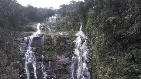
Photo
Where is located Cachoeira da Água Branca
Cachoeira da Água Branca — local attraction, which is located at Ubatuba, State of São Paulo, 11680-000, Brazil and belongs to the category — nature preserve. Average visitor rating for this place — 4.8 (according to 32 ratings, information from open sources and relevant for 2022).
Exact location — Cachoeira da Água Branca, marked on the map with a red marker.
You can get directions to Cachoeira da Água Branca on the map from your location.
What else is interesting in Ubatuba? You can see all the sights if you go to the city page.
Coordinates
Cachoeira da Água Branca, Brazil coordinates in decimal format: latitude — -23.488552864013368, longitude — -45.25758257547421. When converted to degrees, minutes, seconds Cachoeira da Água Branca has the following coordinates: -23°29′18.79 north latitude and -45°15′27.3 east longitude.
Nearby cities
The largest cities that are located nearby:
- Taubaté — 66 km
- Pindamonhangaba — 68 km
- Guaratinguetá — 70 km
- São José dos Campos — 86 km
- Jacareí — 91 km
- Angra dos Reis — 91 km
- Mogi das Cruzes — 112 km
- Resende — 125 km
- Suzano — 125 km
- Itaquaquecetuba — 128 km
- Poá — 129 km
- Guarujá — 134 km
- Barra Mansa — 135 km
- Ribeirão Pires — 137 km
- Santos — 139 km
- Mauá — 142 km
- Volta Redonda — 144 km
- Cubatão — 145 km
- São Vicente — 145 km