
 Bel-Ha
San Jose El Alto
El Porvenir
Nueva Palestina
Santa Lucía
Chemax
La Morita
Temoac
Zacualpan
Bel-Ha
San Jose El Alto
El Porvenir
Nueva Palestina
Santa Lucía
Chemax
La Morita
Temoac
Zacualpan
Iglesia de la Compañía on the map, Pátzcuaro, Mexico
Photo
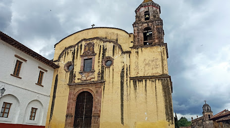
Where is located Iglesia de la Compañía
Iglesia de la Compañía — local attraction, which is located at Enseñanza, Colimillas, 61606 Pátzcuaro, Mich., Mexico and belongs to the category — catholic church. Average visitor rating for this place — 4.5 (according to 62 ratings, information from open sources and relevant for 2022).
Exact location — Iglesia de la Compañía, marked on the map with a red marker.
You can get directions to Iglesia de la Compañía on the map from your location.
What else is interesting in Pátzcuaro? You can see all the sights if you go to the city page.
Coordinates
Iglesia de la Compañía, Mexico coordinates in decimal format: latitude — 19.512899579968455, longitude — -101.60749557554259. When converted to degrees, minutes, seconds Iglesia de la Compañía has the following coordinates: 19°30′46.44 north latitude and -101°36′26.98 east longitude.
Nearby cities
The largest cities that are located nearby:
- Uruapan — 47 km
- Morelia — 48 km
- Zamora — 88 km
- Salamanca — 124 km
- Irapuato — 131 km
- Celaya — 139 km
- Santiago de Querétaro — 173 km
- León — 178 km
- San Juan del Río — 194 km
- Toluca — 205 km
- Tonalá — 209 km
- Metepec — 212 km
- Tlaquepaque — 216 km
- Guadalajara — 220 km
- Colima — 223 km
- Zapopan — 227 km
- Ciudad López Mateos — 244 km
- Cuautitlán Izcalli — 246 km
- Naucalpan — 248 km
Distance to the capital
Distance to the capital (Mexico City) is about — 260 km.