
 Bel-Ha
San Jose El Alto
El Porvenir
Nueva Palestina
Santa Lucía
Chemax
La Morita
Temoac
Zacualpan
Bel-Ha
San Jose El Alto
El Porvenir
Nueva Palestina
Santa Lucía
Chemax
La Morita
Temoac
Zacualpan
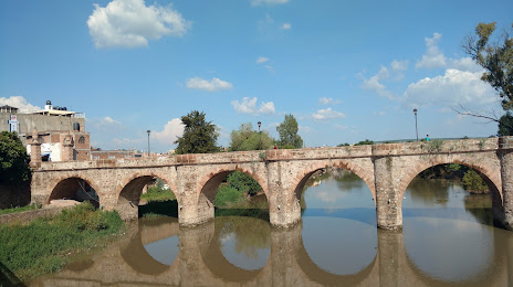
Puente Cavadas on the map, La Piedad, Mexico
Photo
Where is located Puente Cavadas
Puente Cavadas — local attraction, which is located at Calle Pedro Chavolla Eje Nte, Centro, 59300 La Piedad de Cavadas, Gto., Mexico and belongs to the category — archaeological site. Average visitor rating for this place — 4.2 (according to 220 ratings, information from open sources and relevant for 2022).
Exact location — Puente Cavadas, marked on the map with a red marker.
You can get directions to Puente Cavadas on the map from your location.
What else is interesting in La Piedad? You can see all the sights if you go to the city page.
Coordinates
Puente Cavadas, Mexico coordinates in decimal format: latitude — 20.342927617888893, longitude — -102.01997767552932. When converted to degrees, minutes, seconds Puente Cavadas has the following coordinates: 20°20′34.54 north latitude and -102°1′11.92 east longitude.
Nearby cities
The largest cities that are located nearby:
- Zamora — 45 km
- Irapuato — 81 km
- Salamanca — 92 km
- León — 95 km
- Uruapan — 102 km
- Morelia — 113 km
- Tonalá — 128 km
- Celaya — 130 km
- Tlaquepaque — 135 km
- Guadalajara — 139 km
- Zapopan — 146 km
- Aguascalientes — 174 km
- Santiago de Querétaro — 174 km
- Colima — 212 km
- San Juan del Río — 214 km
- San Luis Potosi — 229 km
- Soledad de Graciano Sánchez — 234 km
- Manzanillo — 275 km
- Zacatecas — 275 km
Distance to the capital
Distance to the capital (Mexico City) is about — 318 km.