 Bel-Ha
San Jose El Alto
El Porvenir
Nueva Palestina
Santa Lucía
Chemax
La Morita
Temoac
Zacualpan
Bel-Ha
San Jose El Alto
El Porvenir
Nueva Palestina
Santa Lucía
Chemax
La Morita
Temoac
Zacualpan
Cerro El Vígia on the map, Guaymas, Mexico
Photo
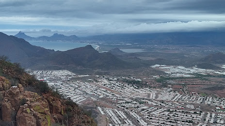
Where is located Cerro El Vígia
Cerro El Vígia — local attraction, which is located at Camino a Microondas, Heroica Guaymas, Son., Mexico and belongs to the category — national park. Average visitor rating for this place — 4.6 (according to 69 ratings, information from open sources and relevant for 2022).
Exact location — Cerro El Vígia, marked on the map with a red marker.
You can get directions to Cerro El Vígia on the map from your location.
What else is interesting in Guaymas? You can see all the sights if you go to the city page.
Coordinates
Cerro El Vígia, Mexico coordinates in decimal format: latitude — 27.93382390603046, longitude — -110.90023733625263. When converted to degrees, minutes, seconds Cerro El Vígia has the following coordinates: 27°56′1.77 north latitude and -110°54′0.85 east longitude.
Nearby cities
The largest cities that are located nearby:
- Ciudad Obregón — 107 km
- Hermosillo — 128 km
- Navojoa — 171 km
- Los Mochis — 303 km
- Nogales
 (United States) — 378 km
 - La Paz — 422 km
- Chihuahua — 475 km
- Tucson (United States) — 476 km
- Delicias — 530 km
- Ciudad Juarez — 593 km
- El Paso (United States) — 598 km
- Chandler (United States) — 602 km
- Gilbert (United States) — 606 km
- Mesa (United States) — 614 km
- Tempe (United States) — 616 km
- San Luis Río Colorado — 618 km
- Phoenix (United States) — 621 km
- Scottsdale (United States) — 624 km
- Glendale (United States) — 633 km
Distance to the capital
Distance to the capital (Mexico City) is about — 1525 km.