
 Manuel María Caballero
Santa Cruz Department
Pozo del Tigre
Motacucito
Colquiri
Inquisivi
Provincia de Andrés Ibáñez
Yacuíba
Tarija
Manuel María Caballero
Santa Cruz Department
Pozo del Tigre
Motacucito
Colquiri
Inquisivi
Provincia de Andrés Ibáñez
Yacuíba
Tarija
Torre Eiffel Parque Bolívar on the map, Sucre, Bolivia
Photo
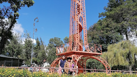
Where is located Torre Eiffel Parque Bolívar
Torre Eiffel Parque Bolívar — local attraction, which is located at Km. 7 356, Sucre, Bolivia and belongs to the category — historical landmark. Average visitor rating for this place — 4.4 (according to 185 ratings, information from open sources and relevant for 2022).
Exact location — Torre Eiffel Parque Bolívar, marked on the map with a red marker.
You can get directions to Torre Eiffel Parque Bolívar on the map from your location.
What else is interesting in Sucre? You can see all the sights if you go to the city page.
Coordinates
Torre Eiffel Parque Bolívar, Bolivia coordinates in decimal format: latitude — -19.041947325004905, longitude — -65.26435852555002. When converted to degrees, minutes, seconds Torre Eiffel Parque Bolívar has the following coordinates: -19°2′31.01 north latitude and -65°15′51.69 east longitude.
Nearby cities
The largest cities that are located nearby:
- Potosi — 80 km
- Cochabamba — 205 km
- Oruro — 227 km
- Santa Cruz de la Sierra — 270 km
- Tarija — 283 km
- Iquique
 (Chile) — 523 km
 - Calama (Chile) — 533 km
- Arica (Chile) — 533 km
- Tacna
 (Peru) — 536 km
 - San Salvador de Jujuy
 (Argentina) — 571 km
 - Fist (Peru) — 616 km
- Salta (Argentina) — 637 km
- Juliaca (Peru) — 648 km
- Arequipa (Peru) — 725 km
- Antofagasta (Chile) — 730 km
- San Miguel de Tucuman (Argentina) — 861 km
- Cusco (Peru) — 942 km
- Santiago del Estero (Argentina) — 974 km
- Asuncion
 (Paraguay) — 1030 km
Distance to the capital
Distance to the capital (Nuestra Señora de La Paz) is about — 416 km.