
 Bokamoso
Buysdorp
Xihosana
Ga-Sekororo
Ga-Rankuwa
Three Sisters
George
Haenertsburg
Polokwane
Bokamoso
Buysdorp
Xihosana
Ga-Sekororo
Ga-Rankuwa
Three Sisters
George
Haenertsburg
Polokwane
Royal Port Alfred Golf Club on the map, Port Alfred, South Africa
Photo
Where is located Royal Port Alfred Golf Club
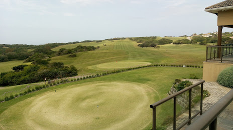
Royal Port Alfred Golf Club — local attraction, which is located at 7 St Andrews Rd, Port Alfred, 6170, South Africa and belongs to the category — golf club. Average visitor rating for this place — 4.5 (according to 178 ratings, information from open sources and relevant for 2022).
Exact location — Royal Port Alfred Golf Club, marked on the map with a red marker.
You can get directions to Royal Port Alfred Golf Club on the map from your location.
What else is interesting in Port Alfred? You can see all the sights if you go to the city page.
Coordinates
Royal Port Alfred Golf Club, South Africa coordinates in decimal format: latitude — -33.60338579239965, longitude — 26.884525124752777. When converted to degrees, minutes, seconds Royal Port Alfred Golf Club has the following coordinates: -33°36′12.19 north latitude and 26°53′4.29 east longitude.
Nearby cities
The largest cities that are located nearby:
- Bisho — 98 km
- East London — 114 km
- Port Elizabeth — 124 km
- Uitenhage — 136 km
- Queenstown — 188 km
- George — 409 km
- Mossel Bay — 439 km
- Maseru
 (Lesotho) — 478 km
 - Botshabelo — 479 km
- Bloemfontein — 500 km
- Pietermaritzburg — 555 km
- Durban — 573 km
- Kimberley — 575 km
- Virginia — 607 km
- Welkom — 621 km
- Kroonstad — 659 km
- Worcester — 685 km
- Newcastle — 713 km
- Paarl — 729 km
Distance to the capital
Distance to the capital (Pretoria) is about — 883 km.