
 Bokamoso
Buysdorp
Xihosana
Ga-Sekororo
Ga-Rankuwa
Three Sisters
George
Haenertsburg
Polokwane
Bokamoso
Buysdorp
Xihosana
Ga-Sekororo
Ga-Rankuwa
Three Sisters
George
Haenertsburg
Polokwane
Oppenheimer Gardens on the map, Kimberley, South Africa
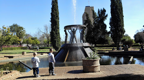
Photo
Where is located Oppenheimer Gardens
Oppenheimer Gardens — local attraction, which is located at Jan Smuts Blvd, Civic Centre, Kimberley, 8300, South Africa and belongs to the category — park. Average visitor rating for this place — 3.5 (according to 281 rating, information from open sources and relevant for 2022).
Exact location — Oppenheimer Gardens, marked on the map with a red marker.
You can get directions to Oppenheimer Gardens on the map from your location.
What else is interesting in Kimberley? You can see all the sights if you go to the city page.
Coordinates
Oppenheimer Gardens, South Africa coordinates in decimal format: latitude — -28.744281212858517, longitude — 24.767662924634568. When converted to degrees, minutes, seconds Oppenheimer Gardens has the following coordinates: -28°44′39.41 north latitude and 24°46′3.59 east longitude.
Nearby cities
The largest cities that are located nearby:
- Bloemfontein — 146 km
- Botshabelo — 197 km
- Welkom — 208 km
- Virginia — 215 km
- Maseru
 (Lesotho) — 269 km
 - Kroonstad — 270 km
- Orkney — 270 km
- Klerksdorp — 277 km
- Potchefstroom — 321 km
- Carletonville — 370 km
- Vanderbijlpark — 378 km
- Vereeniging — 387 km
- Westonaria — 392 km
- Queenstown — 403 km
- Randfontein — 406 km
- Soweto — 412 km
- Krugersdorp — 417 km
- Rustenburg — 422 km
- Roodepoort — 425 km
Distance to the capital
Distance to the capital (Pretoria) is about — 475 km.