
 Bokamoso
Buysdorp
Xihosana
Ga-Sekororo
Ga-Rankuwa
Three Sisters
George
Haenertsburg
Polokwane
Bokamoso
Buysdorp
Xihosana
Ga-Sekororo
Ga-Rankuwa
Three Sisters
George
Haenertsburg
Polokwane
Lang Elsie's Kraal Rest Camp on the map, Swellendam, South Africa
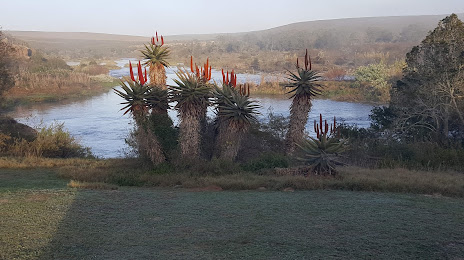
Photo
Where is located Lang Elsie's Kraal Rest Camp
Lang Elsie's Kraal Rest Camp — local attraction, which is located at Swellendam, 6740, South Africa and belongs to the category — national park. Average visitor rating for this place — 4.4 (according to 27 ratings, information from open sources and relevant for 2022).
Exact location — Lang Elsie's Kraal Rest Camp, marked on the map with a red marker.
You can get directions to Lang Elsie's Kraal Rest Camp on the map from your location.
What else is interesting in Swellendam? You can see all the sights if you go to the city page.
Coordinates
Lang Elsie's Kraal Rest Camp, South Africa coordinates in decimal format: latitude — -34.076183370412075, longitude — 20.454825024765054. When converted to degrees, minutes, seconds Lang Elsie's Kraal Rest Camp has the following coordinates: -34°4′34.26 north latitude and 20°27′17.37 east longitude.
Nearby cities
The largest cities that are located nearby:
- Worcester — 101 km
- Paarl — 140 km
- Mossel Bay — 156 km
- Cape Town — 185 km
- George — 185 km
- Uitenhage — 459 km
- Port Elizabeth — 474 km
- Queenstown — 654 km
- Bisho — 664 km
- East London — 699 km
- Kimberley — 721 km
- Bloemfontein — 779 km
- Botshabelo — 804 km
- Maseru
 (Lesotho) — 857 km
 - Virginia — 906 km
- Welkom — 908 km
- Kroonstad — 970 km
- Orkney — 993 km
- Klerksdorp — 1001 km
Distance to the capital
Distance to the capital (Pretoria) is about — 1188 km.