
 Bokamoso
Buysdorp
Xihosana
Ga-Sekororo
Ga-Rankuwa
Three Sisters
George
Haenertsburg
Polokwane
Bokamoso
Buysdorp
Xihosana
Ga-Sekororo
Ga-Rankuwa
Three Sisters
George
Haenertsburg
Polokwane
St Luke's Anglican Church on the map, Howick, South Africa
Photo
Where is located St Luke's Anglican Church
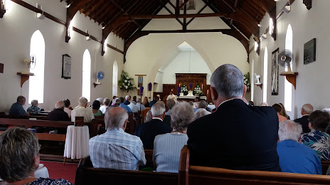
St Luke's Anglican Church — local attraction, which is located at 18 Main Rd, Howick, 3290, South Africa and belongs to the category — anglican church. Average visitor rating for this place — 4.4 (according to 5 ratings, information from open sources and relevant for 2022).
Exact location — St Luke's Anglican Church, marked on the map with a red marker.
You can get directions to St Luke's Anglican Church on the map from your location.
What else is interesting in Howick? You can see all the sights if you go to the city page.
Coordinates
St Luke's Anglican Church, South Africa coordinates in decimal format: latitude — -29.484736608995128, longitude — 30.234908124651543. When converted to degrees, minutes, seconds St Luke's Anglican Church has the following coordinates: -29°29′5.05 north latitude and 30°14′5.67 east longitude.
Nearby cities
The largest cities that are located nearby:
- Pietermaritzburg — 20 km
- Durban — 87 km
- Richards Bay — 193 km
- Newcastle — 195 km
- Vryheid — 199 km
- Maseru
 (Lesotho) — 265 km
 - Botshabelo — 338 km
- Bethal — 343 km
- Embalenhle — 344 km
- Manzini
 (Swaziland) — 349 km
 - Kroonstad — 356 km
- Virginia — 362 km
- Welkom — 380 km
- Nigel — 384 km
- Vereeniging — 385 km
- Vanderbijlpark — 388 km
- Bloemfontein — 389 km
- Springs — 399 km
- Queenstown — 408 km
Distance to the capital
Distance to the capital (Pretoria) is about — 462 km.