
 Litoral Del Bajo San Juan
El Cantón de San Pablo
Juan Frío
Santa Barbara
El Juncal
Dibulla
Vereda Campo Alegre
San Pablo
Guaramito
Litoral Del Bajo San Juan
El Cantón de San Pablo
Juan Frío
Santa Barbara
El Juncal
Dibulla
Vereda Campo Alegre
San Pablo
Guaramito
Páramo de Sonsón on the map, Sonson, Colombia
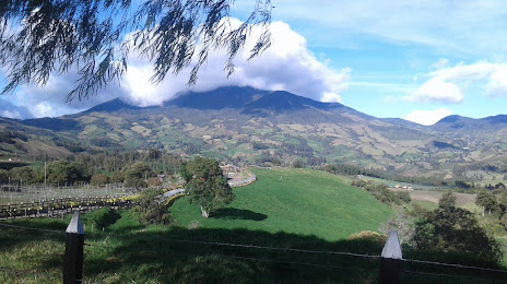
Photo
Where is located Páramo de Sonsón
Páramo de Sonsón — local attraction, which is located at Cra. 5 #10-29, Sonsón, Antioquia, Colombia and belongs to the category — nature preserve. Average visitor rating for this place — 4.5 (according to 34 ratings, information from open sources and relevant for 2022).
Exact location — Páramo de Sonsón, marked on the map with a red marker.
You can get directions to Páramo de Sonsón on the map from your location.
What else is interesting in Sonson? You can see all the sights if you go to the city page.
Coordinates
Páramo de Sonsón, Colombia coordinates in decimal format: latitude — 5.716282017505564, longitude — -75.25051515562768. When converted to degrees, minutes, seconds Páramo de Sonsón has the following coordinates: 5°42′58.62 north latitude and -75°15′1.85 east longitude.
Nearby cities
The largest cities that are located nearby:
- Envigado — 60 km
- Itagüi — 61 km
- Medellín — 68 km
- Bello — 74 km
- Manizales — 75 km
- Dos Quebradas — 104 km
- Pereira — 108 km
- Cartago — 125 km
- Armenia — 136 km
- Ibagué — 141 km
- Girardot — 166 km
- Soacha — 173 km
- Tuluá — 204 km
- Tunja — 217 km
- Barrancabermeja — 219 km
- Buga — 228 km
- Villavicencio — 254 km
- Sogamoso — 262 km
- Palmira — 264 km
Distance to the capital
Distance to the capital (Bogota) is about — 180 km.