
 Belém
Maranguape
Paranaguá
Paranaguá
Monte Alegre
Alvorada de Minas
Bragança
Laguna
Ibiporã
Belém
Maranguape
Paranaguá
Paranaguá
Monte Alegre
Alvorada de Minas
Bragança
Laguna
Ibiporã
Parque Municipal on the map, Urussanga, Brazil
Photo
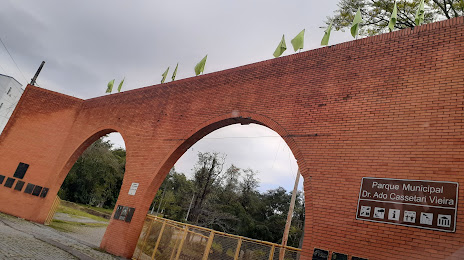
Where is located Parque Municipal
Parque Municipal — local attraction, which is located at Pc da Banderia, 12 - Centro, Urussanga - SC, 88840-000, Brazil and belongs to the category — park. Average visitor rating for this place — 4.5 (according to 294 ratings, information from open sources and relevant for 2022).
Exact location — Parque Municipal, marked on the map with a red marker.
You can get directions to Parque Municipal on the map from your location.
What else is interesting in Urussanga? You can see all the sights if you go to the city page.
Coordinates
Parque Municipal, Brazil coordinates in decimal format: latitude — -28.526988000692615, longitude — -49.32485197537029. When converted to degrees, minutes, seconds Parque Municipal has the following coordinates: -28°31′37.16 north latitude and -49°19′29.47 east longitude.
Nearby cities
The largest cities that are located nearby:
- Criciúma — 17 km
- Palhoça — 116 km
- São José — 121 km
- Lages — 126 km
- Florianópolis — 128 km
- Blumenau — 180 km
- Itajaí — 190 km
- Caxias do Sul — 193 km
- Novo Hamburgo — 216 km
- São Leopoldo — 222 km
- Gravataí — 224 km
- Jaraguá do Sul — 227 km
- Cachoeirinha — 232 km
- Canoas — 236 km
- Viamão — 237 km
- Porto Alegre — 247 km
- Joinville — 250 km
- Guaíba — 259 km
- Passo Fundo — 302 km