
 Belém
Maranguape
Paranaguá
Paranaguá
Monte Alegre
Alvorada de Minas
Bragança
Laguna
Ibiporã
Belém
Maranguape
Paranaguá
Paranaguá
Monte Alegre
Alvorada de Minas
Bragança
Laguna
Ibiporã
Centro Histórico de Canavieiras on the map, Canavieiras, Brazil
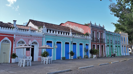
Photo
Where is located Centro Histórico de Canavieiras
Centro Histórico de Canavieiras — local attraction, which is located at Canavieiras, State of Bahia, 45860-000, Brazil and belongs to the category — historical landmark. Average visitor rating for this place — 4.6 (according to 106 ratings, information from open sources and relevant for 2022).
Exact location — Centro Histórico de Canavieiras, marked on the map with a red marker.
You can get directions to Centro Histórico de Canavieiras on the map from your location.
What else is interesting in Canavieiras? You can see all the sights if you go to the city page.
Coordinates
Centro Histórico de Canavieiras, Brazil coordinates in decimal format: latitude — -15.68124407192888, longitude — -38.94460767559704. When converted to degrees, minutes, seconds Centro Histórico de Canavieiras has the following coordinates: -15°40′52.48 north latitude and -38°56′40.59 east longitude.
Nearby cities
The largest cities that are located nearby:
- Porto Seguro — 86 km
- Ilhéus — 98 km
- Itabuna — 105 km
- Vitória da Conquista — 222 km
- Jequié — 235 km
- Salvador — 303 km
- Lauro de Freitas — 316 km
- Camaçari — 336 km
- Teófilo Otoni — 362 km
- Feira de Santana — 378 km
- Alagoinhas — 396 km
- Linhares — 427 km
- Colatina — 461 km
- Valadares Governor — 472 km
- Serra — 511 km
- Cariacica — 530 km
- Montes Claros — 533 km
- Vila Velha — 535 km
- Aracaju — 561 km