
 Belém
Maranguape
Paranaguá
Paranaguá
Monte Alegre
Alvorada de Minas
Bragança
Laguna
Ibiporã
Belém
Maranguape
Paranaguá
Paranaguá
Monte Alegre
Alvorada de Minas
Bragança
Laguna
Ibiporã
Praia da Santa on the map, Porto Franco, Brazil
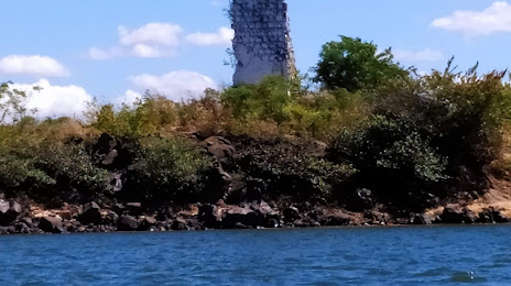
Photo
Where is located Praia da Santa
Praia da Santa — local attraction, which is located at Tocantinópolis - State of Tocantins, 77900-000, Brazil and belongs to the category — tourist attraction. Average visitor rating for this place — 4.6 (according to 169 ratings, information from open sources and relevant for 2022).
Exact location — Praia da Santa, marked on the map with a red marker.
You can get directions to Praia da Santa on the map from your location.
What else is interesting in Porto Franco? You can see all the sights if you go to the city page.
Coordinates
Praia da Santa, Brazil coordinates in decimal format: latitude — -6.328370480990964, longitude — -47.41009887568082. When converted to degrees, minutes, seconds Praia da Santa has the following coordinates: -6°19′42.13 north latitude and -47°24′36.36 east longitude.
Nearby cities
The largest cities that are located nearby:
- Imperatriz — 91 km
- Araguaína — 129 km
- Marabá — 219 km
- Palmas — 444 km
- Caxias — 473 km
- Timon — 521 km
- Teresina — 524 km
- São Luís — 543 km
- Belém — 554 km
- Castanhal — 561 km
- Ananindeua — 561 km
- Barreiras — 692 km
- Parnaíba — 728 km
- Macapá — 814 km
- Petrolina — 824 km
- Juazeiro do Norte — 892 km
- Santarém — 914 km
- Maracanaú — 1005 km
- Caucaia — 1006 km