
 Belém
Maranguape
Paranaguá
Paranaguá
Monte Alegre
Alvorada de Minas
Bragança
Laguna
Ibiporã
Belém
Maranguape
Paranaguá
Paranaguá
Monte Alegre
Alvorada de Minas
Bragança
Laguna
Ibiporã
Ramubrinká - Beach Park on the map, Aquiraz, Brazil
Photo
Where is located Ramubrinká - Beach Park
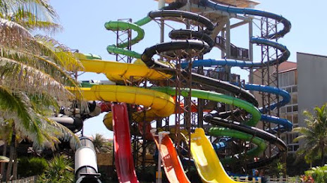
Ramubrinká - Beach Park — local attraction, which is located at Av. dos Golfinhos, 20 - Porto das Dunas, Aquiraz - CE, 61700-000, Brazil and belongs to the category — tourist attraction. Average visitor rating for this place — 4.8 (according to 846 ratings, information from open sources and relevant for 2022).
Exact location — Ramubrinká - Beach Park, marked on the map with a red marker.
You can get directions to Ramubrinká - Beach Park on the map from your location.
What else is interesting in Aquiraz? You can see all the sights if you go to the city page.
Coordinates
Ramubrinká - Beach Park, Brazil coordinates in decimal format: latitude — -3.8428411184168114, longitude — -38.39102182569123. When converted to degrees, minutes, seconds Ramubrinká - Beach Park has the following coordinates: -3°50′34.23 north latitude and -38°23′27.68 east longitude.
Nearby cities
The largest cities that are located nearby:
- Fortaleza — 24 km
- Maracanaú — 26 km
- Caucaia — 36 km
- Mossoro — 183 km
- Juazeiro do Norte — 382 km
- Parnaíba — 389 km
- Natal — 408 km
- Parnamirim — 409 km
- Campina Grande — 459 km
- Teresina — 504 km
- Timon — 507 km
- Santa Rita — 519 km
- João Pessoa — 527 km
- Caruaru — 552 km
- Caxias — 558 km
- Camaragibe — 589 km
- Recife — 599 km
- Jaboatão dos Guararapes — 601 km
- Petrolina — 649 km