
 Belém
Maranguape
Paranaguá
Paranaguá
Monte Alegre
Alvorada de Minas
Bragança
Laguna
Ibiporã
Belém
Maranguape
Paranaguá
Paranaguá
Monte Alegre
Alvorada de Minas
Bragança
Laguna
Ibiporã
Engenho Cunhaú on the map, Canguaretama, Brazil
Photo
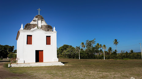
Where is located Engenho Cunhaú
Engenho Cunhaú — local attraction, which is located at Canguaretama - State of Rio Grande do Norte, 59190-000, Brazil and belongs to the category — historical landmark. Average visitor rating for this place — 4.7 (according to 54 ratings, information from open sources and relevant for 2022).
Exact location — Engenho Cunhaú, marked on the map with a red marker.
You can get directions to Engenho Cunhaú on the map from your location.
What else is interesting in Canguaretama? You can see all the sights if you go to the city page.
Coordinates
Engenho Cunhaú, Brazil coordinates in decimal format: latitude — -6.416876572650177, longitude — -35.16183437568046. When converted to degrees, minutes, seconds Engenho Cunhaú has the following coordinates: -6°25′0.76 north latitude and -35°9′42.6 east longitude.
Nearby cities
The largest cities that are located nearby:
- Parnamirim — 54 km
- Natal — 67 km
- Santa Rita — 85 km
- João Pessoa — 87 km
- Campina Grande — 124 km
- Camaragibe — 182 km
- Recife — 187 km
- Jaboatão dos Guararapes — 199 km
- Caruaru — 230 km
- Mossoro — 278 km
- Maceió — 367 km
- Arapiraca — 409 km
- Juazeiro do Norte — 468 km
- Maracanaú — 475 km
- Fortaleza — 476 km
- Caucaia — 488 km
- Aracaju — 547 km
- Petrolina — 674 km
- Alagoinhas — 729 km