
 Belém
Maranguape
Paranaguá
Paranaguá
Monte Alegre
Alvorada de Minas
Bragança
Laguna
Ibiporã
Belém
Maranguape
Paranaguá
Paranaguá
Monte Alegre
Alvorada de Minas
Bragança
Laguna
Ibiporã
Church of San Sebastian on the map, Morretes, Brazil
Photo
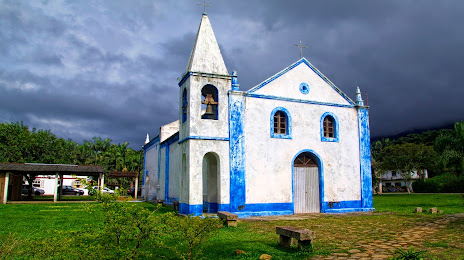
Where is located Church of San Sebastian
Church of San Sebastian — local attraction, which is located at Parque Breckenfeld, Morretes - State of Paraná, 83350-000, Brazil and belongs to the category — catholic church. Average visitor rating for this place — 4.6 (according to 79 ratings, information from open sources and relevant for 2022).
Exact location — Church of San Sebastian, marked on the map with a red marker.
You can get directions to Church of San Sebastian on the map from your location.
What else is interesting in Morretes? You can see all the sights if you go to the city page.
Coordinates
Church of San Sebastian, Brazil coordinates in decimal format: latitude — -25.463624684466637, longitude — -48.85051019085744. When converted to degrees, minutes, seconds Church of San Sebastian has the following coordinates: -25°27′49.05 north latitude and -48°51′1.84 east longitude.
Nearby cities
The largest cities that are located nearby:
- Paranaguá — 31 km
- Pinhais — 37 km
- São José dos Pinhais — 38 km
- Curitiba — 44 km
- Colombo — 45 km
- Araucária — 59 km
- Joinville — 91 km
- Jaraguá do Sul — 113 km
- Itajaí — 159 km
- Blumenau — 160 km
- Itapetininga — 224 km
- Florianópolis — 235 km
- São José — 236 km
- Palhoça — 240 km
- Sorocaba — 260 km
- Guarapuava — 263 km
- Cotia — 284 km
- Itapevi — 287 km
- Botucatu — 290 km