
 Belém
Maranguape
Paranaguá
Paranaguá
Monte Alegre
Alvorada de Minas
Bragança
Laguna
Ibiporã
Belém
Maranguape
Paranaguá
Paranaguá
Monte Alegre
Alvorada de Minas
Bragança
Laguna
Ibiporã
Serra da Tormenta on the map, Carmo do Rio Claro, Brazil
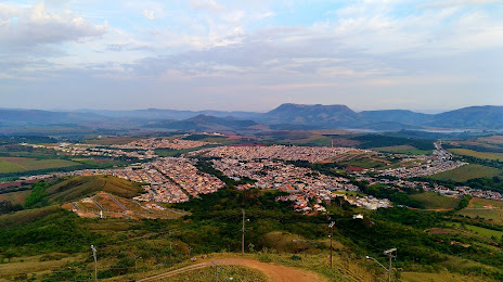
Photo
Where is located Serra da Tormenta
Serra da Tormenta — local attraction, which is located at Carmo do Rio Claro, State of Minas Gerais, 37150-000, Brazil and belongs to the category — scenic spot. Average visitor rating for this place — 4.8 (according to 225 ratings, information from open sources and relevant for 2022).
Exact location — Serra da Tormenta, marked on the map with a red marker.
You can get directions to Serra da Tormenta on the map from your location.
What else is interesting in Carmo do Rio Claro? You can see all the sights if you go to the city page.
Coordinates
Serra da Tormenta, Brazil coordinates in decimal format: latitude — -20.990175462032408, longitude — -46.10537757551865. When converted to degrees, minutes, seconds Serra da Tormenta has the following coordinates: -20°59′24.63 north latitude and -46°6′19.36 east longitude.
Nearby cities
The largest cities that are located nearby:
- Poços de Caldas — 101 km
- Franca — 141 km
- Divinópolis — 157 km
- Ribeirão Preto — 176 km
- Araras — 200 km
- São Carlos — 215 km
- Rio Claro — 217 km
- Guaratinguetá — 224 km
- Pindamonhangaba — 226 km
- Betim — 228 km
- Araraquara — 230 km
- Americana — 231 km
- Uberaba — 233 km
- Taubaté — 233 km
- Campinas — 235 km
- Sumaré — 236 km
- Hortolândia — 236 km
- Santa Bárbara D'Oeste — 237 km
- Resende — 238 km