
 Manuel María Caballero
Santa Cruz Department
Pozo del Tigre
Motacucito
Colquiri
Inquisivi
Provincia de Andrés Ibáñez
Yacuíba
Tarija
Manuel María Caballero
Santa Cruz Department
Pozo del Tigre
Motacucito
Colquiri
Inquisivi
Provincia de Andrés Ibáñez
Yacuíba
Tarija
Canal Tamengo on the map, Puerto Suárez, Bolivia
Photo
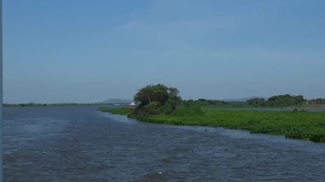
Where is located Canal Tamengo
Canal Tamengo — local attraction, which is located at no data and belongs to the category — -. Average visitor rating for this place — 5.0 (according to 2 ratings, information from open sources and relevant for 2022).
Exact location — Canal Tamengo, marked on the map with a red marker.
You can get directions to Canal Tamengo on the map from your location.
What else is interesting in Puerto Suárez? You can see all the sights if you go to the city page.
Coordinates
Canal Tamengo, Bolivia coordinates in decimal format: latitude — -19.000364071297415, longitude — -57.7005151470254. When converted to degrees, minutes, seconds Canal Tamengo has the following coordinates: -19°0′1.31 north latitude and -57°42′1.85 east longitude.
Nearby cities
The largest cities that are located nearby:
- Campo Grande
 (Brazil) — 369 km
 - Várzea Grande (Brazil) — 408 km
- Cuiaba (Brazil) — 414 km
- Rondonópolis (Brazil) — 434 km
- Dourados (Brazil) — 472 km
- Santa Cruz de la Sierra — 561 km
- Luque
 (Paraguay) — 698 km
 - Asuncion (Paraguay) — 698 km
- Fernando De La Mora (Paraguay) — 703 km
- San Lorenzo (Paraguay) — 705 km
- Lambare (Paraguay) — 706 km
- Capiata (Paraguay) — 709 km
- Presidente Prudente (Brazil) — 743 km
- Tarija — 768 km
- Maringá (Brazil) — 772 km
- Sucre — 780 km
- Ciudad del Este (Paraguay) — 791 km
- Foz do Iguaçu (Brazil) — 792 km
- Cascavel (Brazil) — 792 km
Distance to the capital
Distance to the capital (Nuestra Señora de La Paz) is about — 1141 km.