
 Litoral Del Bajo San Juan
El Cantón de San Pablo
Juan Frío
Santa Barbara
El Juncal
Dibulla
Vereda Campo Alegre
San Pablo
Guaramito
Litoral Del Bajo San Juan
El Cantón de San Pablo
Juan Frío
Santa Barbara
El Juncal
Dibulla
Vereda Campo Alegre
San Pablo
Guaramito
Natural Serranía De Los Yariguíes National Park on the map, San Vicente De Chucurí, Colombia
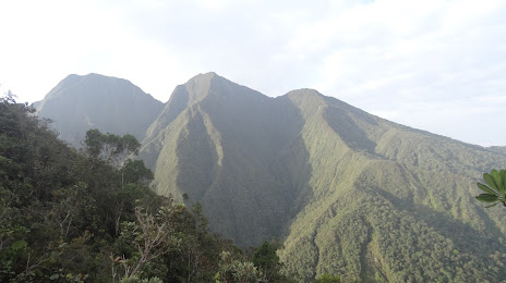
Photo
Where is located Natural Serranía De Los Yariguíes National Park
Natural Serranía De Los Yariguíes National Park — local attraction, which is located at Santander, Colombia and belongs to the category — park. Average visitor rating for this place — 4.6 (according to 71 rating, information from open sources and relevant for 2022).
Exact location — Natural Serranía De Los Yariguíes National Park, marked on the map with a red marker.
You can get directions to Natural Serranía De Los Yariguíes National Park on the map from your location.
What else is interesting in San Vicente De Chucurí? You can see all the sights if you go to the city page.
Coordinates
Natural Serranía De Los Yariguíes National Park, Colombia coordinates in decimal format: latitude — 6.844967632114713, longitude — -73.29868858678822. When converted to degrees, minutes, seconds Natural Serranía De Los Yariguíes National Park has the following coordinates: 6°50′41.88 north latitude and -73°17′55.28 east longitude.
Nearby cities
The largest cities that are located nearby:
- Giron — 34 km
- Floridablanca — 41 km
- Bucaramanga — 42 km
- Barrancabermeja — 52 km
- Sogamoso — 139 km
- Tunja — 148 km
- Cúcuta — 149 km
- San Cristobal
 (Venezuela) — 163 km
 - Bello — 243 km
- Medellín — 247 km
- Envigado — 252 km
- Itagüi — 255 km
- Soacha — 269 km
- Magangué — 299 km
- Ejido (Venezuela) — 300 km
- Villavicencio — 304 km
- Manizales — 307 km
- Merida (Venezuela) — 312 km
- Girardot — 324 km
Distance to the capital
Distance to the capital (Bogota) is about — 264 km.