
 Gilserberg
Berlin
Bordesholm
Bechtolsheim
Aub
Triptis
Heppenheim
Biblis
Angermünde
Gilserberg
Berlin
Bordesholm
Bechtolsheim
Aub
Triptis
Heppenheim
Biblis
Angermünde
Otzberg Castle on the map, Gross-Umstadt, Germany
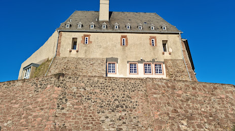
Photo
Where is located Otzberg Castle
Otzberg Castle — local attraction, which is located at Burgweg 28, 64853 Otzberg, Germany and belongs to the category — historical landmark. Average visitor rating for this place — 4.4 (according to 376 ratings, information from open sources and relevant for 2022).
Exact location — Otzberg Castle, marked on the map with a red marker.
You can get directions to Otzberg Castle on the map from your location.
What else is interesting in Gross-Umstadt? You can see all the sights if you go to the city page.
Coordinates
Otzberg Castle, Germany coordinates in decimal format: latitude — 49.819613229485114, longitude — 8.910952725258065. When converted to degrees, minutes, seconds Otzberg Castle has the following coordinates: 49°49′10.61 north latitude and 8°54′39.43 east longitude.
Nearby cities
The largest cities that are located nearby:
- Darmstadt — 20 km
- Offenbach — 27 km
- Frankfurt — 32 km
- Mainz — 50 km
- Mannheim — 54 km
- Wiesbaden — 54 km
- Heidelberg — 55 km
- Ludwigshafen — 56 km
- Würzburg — 74 km
- Heilbronn — 83 km
- Karlsruhe — 103 km
- Koblenz — 109 km
- Pforzheim — 109 km
- Stuttgart — 122 km
- Siegen — 129 km
- Reutlingen — 152 km
- Erlangen — 153 km
- Fürth — 154 km
- Saarbrücken — 156 km
Distance to the capital
Distance to the capital (Berlin) is about — 434 km.