
 Belém
Maranguape
Paranaguá
Paranaguá
Monte Alegre
Alvorada de Minas
Bragança
Laguna
Ibiporã
Belém
Maranguape
Paranaguá
Paranaguá
Monte Alegre
Alvorada de Minas
Bragança
Laguna
Ibiporã
Parque das Trilhas on the map, Pacoti, Brazil
Photo
Where is located Parque das Trilhas
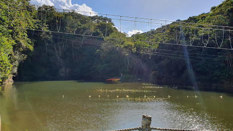
Parque das Trilhas — local attraction, which is located at Estr. do Sítio Suzana, S/N - Zona Rural, Guaramiranga - CE, 62766-000, Brazil and belongs to the category — ecological park. Average visitor rating for this place — 4.4 (according to 276 ratings, information from open sources and relevant for 2022).
Exact location — Parque das Trilhas, marked on the map with a red marker.
You can get directions to Parque das Trilhas on the map from your location.
What else is interesting in Pacoti? You can see all the sights if you go to the city page.
Coordinates
Parque das Trilhas, Brazil coordinates in decimal format: latitude — -4.267308942817415, longitude — -38.931746075689794. When converted to degrees, minutes, seconds Parque das Trilhas has the following coordinates: -4°16′2.31 north latitude and -38°55′54.29 east longitude.
Nearby cities
The largest cities that are located nearby:
- Maracanaú — 51 km
- Caucaia — 62 km
- Fortaleza — 70 km
- Mossoro — 203 km
- Juazeiro do Norte — 335 km
- Parnaíba — 347 km
- Teresina — 438 km
- Timon — 441 km
- Parnamirim — 443 km
- Natal — 444 km
- Campina Grande — 471 km
- Caxias — 494 km
- Santa Rita — 540 km
- João Pessoa — 550 km
- Caruaru — 553 km
- Petrolina — 596 km
- Camaragibe — 602 km
- Jaboatão dos Guararapes — 612 km
- Recife — 612 km