
 Puerto de la Duquesa
La Serna de Iguña
Pumalverde
Puentenansa
La Iglesia
Casar de Periedo
Fuengirola
Renedo de Piélagos
Villabanez
Puerto de la Duquesa
La Serna de Iguña
Pumalverde
Puentenansa
La Iglesia
Casar de Periedo
Fuengirola
Renedo de Piélagos
Villabanez
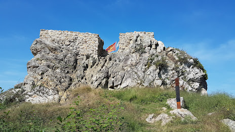
Castillo de Beloaga ( ruinas) on the map, Irun, Spain
Photo
Where is located Castillo de Beloaga ( ruinas)
Castillo de Beloaga ( ruinas) — local attraction, which is located at Arkaleko Bidea, 21A, 20180, Gipuzkoa, Spain and belongs to the category — castle. Average visitor rating for this place — 4.5 (according to 66 ratings, information from open sources and relevant for 2022).
Exact location — Castillo de Beloaga ( ruinas), marked on the map with a red marker.
You can get directions to Castillo de Beloaga ( ruinas) on the map from your location.
What else is interesting in Irun? You can see all the sights if you go to the city page.
Coordinates
Castillo de Beloaga ( ruinas), Spain coordinates in decimal format: latitude — 43.31337485017981, longitude — -1.8448043749638223. When converted to degrees, minutes, seconds Castillo de Beloaga ( ruinas) has the following coordinates: 43°18′48.15 north latitude and -1°50′41.3 east longitude.
Nearby cities
The largest cities that are located nearby:
- San Sebastián — 16 km
- Pamplona — 59 km
- Vitoria-Gasteiz — 90 km
- Bilbao — 93 km
- Logroño — 111 km
- Santander — 163 km
- Burgos — 191 km
- Bordeaux
 (France) — 191 km
 - Zaragoza — 201 km
- Toulouse (France) — 261 km
- Lleida — 275 km
- Valladolid — 306 km
- Gijón — 311 km
- León — 318 km
- Oviedo — 326 km
- Alcala de Henares — 342 km
- Alcobendas — 346 km
- Torrejón de Ardoz — 349 km
- Tarragona — 352 km
Distance to the capital
Distance to the capital (Madrid) is about — 357 km.