 Derrumbadero
La Rancha
San Juan de la Maguana
Espaillat Province
Tábara Arriba
Cibao International Airport
Mao
Punta Cana International Airport
Moca
Derrumbadero
La Rancha
San Juan de la Maguana
Espaillat Province
Tábara Arriba
Cibao International Airport
Mao
Punta Cana International Airport
Moca
Playa los Gringos on the map, Nagua, Dominican Republic
Photo
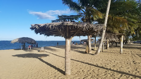
Where is located Playa los Gringos
Playa los Gringos — local attraction, which is located at no data and belongs to the category — -. Average visitor rating for this place — 4.3 (according to 178 ratings, information from open sources and relevant for 2022).
Exact location — Playa los Gringos, marked on the map with a red marker.
You can get directions to Playa los Gringos on the map from your location.
What else is interesting in Nagua? You can see all the sights if you go to the city page.
Coordinates
Playa los Gringos, Dominican Republic coordinates in decimal format: latitude — 19.352863894258878, longitude — -69.81958510616852. When converted to degrees, minutes, seconds Playa los Gringos has the following coordinates: 19°21′10.31 north latitude and -69°49′10.51 east longitude.
Nearby cities
The largest cities that are located nearby:
- San Francisco de Macoris — 42 km
- La Vega — 73 km
- Santiago De Los Caballeros — 89 km
- Puerto Plata — 97 km
- San Cristobal — 109 km
- San Pedro de Macoris — 116 km
- La Romana — 140 km
- Punta Cana — 176 km
- Cap-Haitien
 (Haiti) — 248 km
 - Port-au-Prince (Haiti) — 276 km
- Carrefour (Haiti) — 284 km
- Léogâne (Haiti) — 306 km
- Ponce
 (Puerto Rico) — 373 km
 - Bayamón
 (Puerto Rico) — 401 km
 - Saint John (Puerto Rico) — 406 km
- Carolina (Puerto Rico) — 423 km
- Guantanamo
 (Cuba) — 563 km
 - Santiago de Cuba (Cuba) — 625 km
- Palma Soriano (Cuba) — 643 km
Distance to the capital
Distance to the capital (Santo Domingo) is about — 100 km.