
 Los Mangos
Guangololo
Las Crucitas
Descombros
Santa Elena
Dixon Cove
El Ocotal
Bijagual
Cayo Sierra
Los Mangos
Guangololo
Las Crucitas
Descombros
Santa Elena
Dixon Cove
El Ocotal
Bijagual
Cayo Sierra
Iglesia La Caridad on the map, Comayagua, Honduras
Photo
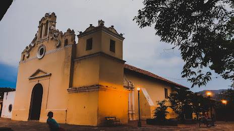
Where is located Iglesia La Caridad
Iglesia La Caridad — local attraction, which is located at Calle 7 NO, Comayagua, Honduras and belongs to the category — church. Average visitor rating for this place — 4.6 (according to 174 ratings, information from open sources and relevant for 2022).
Exact location — Iglesia La Caridad, marked on the map with a red marker.
You can get directions to Iglesia La Caridad on the map from your location.
What else is interesting in Comayagua? You can see all the sights if you go to the city page.
Coordinates
Iglesia La Caridad, Honduras coordinates in decimal format: latitude — 14.463072240176727, longitude — -87.64392957561192. When converted to degrees, minutes, seconds Iglesia La Caridad has the following coordinates: 14°27′47.06 north latitude and -87°38′38.15 east longitude.
Nearby cities
The largest cities that are located nearby:
- El Progreso — 106 km
- San Miguel
 (El Salvador) — 121 km
 - San Pedro Sula — 123 km
- Choloma — 131 km
- La Ceiba — 170 km
- Apopa (El Salvador) — 179 km
- Soyapango (El Salvador) — 180 km
- Mejicanos (El Salvador) — 186 km
- San Salvador (El Salvador) — 188 km
- Santa Tecla (El Salvador) — 196 km
- Chinandega
 (Nicaragua) — 210 km
 - Santa Ana (El Salvador) — 212 km
- Lion (Nicaragua) — 238 km
- Managua (Nicaragua) — 297 km
- Villa Canales
 (Guatemala) — 307 km
 - Guatemala City (Guatemala) — 309 km
- Villa Nueva (Guatemala) — 315 km
- San Juan Sacatepéquez (Guatemala) — 322 km
- Masaya (Nicaragua) — 322 km
Distance to the capital
Distance to the capital (Tegucigalpa) is about — 62 km.