 Pointe-à-la-Croix
Sainte-Irène, Quebec
Marsoui
Hecla
Muskrat Dam
Wunnummin Lake
Sainte-Brigitte-de-Laval
Drayton
Mauricie
Pointe-à-la-Croix
Sainte-Irène, Quebec
Marsoui
Hecla
Muskrat Dam
Wunnummin Lake
Sainte-Brigitte-de-Laval
Drayton
Mauricie
Claybank Brick Plant National Historic Site on the map, Moose Jaw, Canada
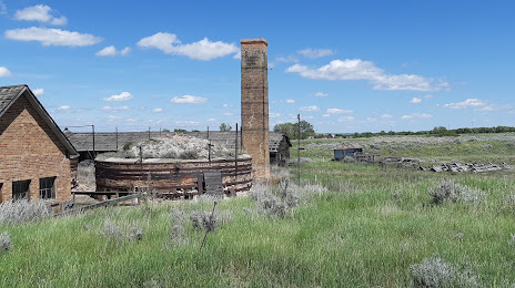
Photo
Where is located Claybank Brick Plant National Historic Site
Claybank Brick Plant National Historic Site — local attraction, which is located at Brick Plant, #1, Claybank, SK S0H 0W0, Canada and belongs to the category — tourist attraction. Average visitor rating for this place — 4.2 (according to 26 ratings, information from open sources and relevant for 2022).
Exact location — Claybank Brick Plant National Historic Site, marked on the map with a red marker.
You can get directions to Claybank Brick Plant National Historic Site on the map from your location.
What else is interesting in Moose Jaw? You can see all the sights if you go to the city page.
Coordinates
Claybank Brick Plant National Historic Site, Canada coordinates in decimal format: latitude — 50.03219996658748, longitude — -105.2142300747343. When converted to degrees, minutes, seconds Claybank Brick Plant National Historic Site has the following coordinates: 50°1′55.92 north latitude and -105°12′51.23 east longitude.
Nearby cities
The largest cities that are located nearby:
- Regina — 66 km
- Saskatoon — 207 km
- Calgary — 598 km
- Winnipeg — 601 km
- Edmonton — 628 km
- Spokane
 (United States) — 936 km
 - Kelowna — 996 km
- Sioux Falls (United States) — 1035 km
- Fort Collins (United States) — 1085 km
- Minneapolis (United States) — 1131 km
- Boise (United States) — 1136 km
- Saint Paul (United States) — 1144 km
- Thornton (United States) — 1164 km
- Westminster (United States) — 1168 km
- Arvada (United States) — 1171 km
- Denver (United States) — 1179 km
- Aurora (United States) — 1180 km
- Lakewood (United States) — 1182 km
- Salt Lake City (United States) — 1190 km
Distance to the capital
Distance to the capital (Ottawa) is about — 2251 km.