
 Belém
Maranguape
Paranaguá
Paranaguá
Monte Alegre
Alvorada de Minas
Bragança
Laguna
Ibiporã
Belém
Maranguape
Paranaguá
Paranaguá
Monte Alegre
Alvorada de Minas
Bragança
Laguna
Ibiporã
Zé Bolo Flô State Park on the map, Cuiaba, Brazil
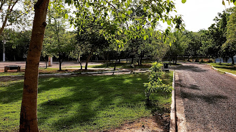
Photo
Where is located Zé Bolo Flô State Park
Zé Bolo Flô State Park — local attraction, which is located at R. Nova Iguaçu, 2 - Coophema, Cuiabá - MT, 78085-118, Brazil and belongs to the category — state park. Average visitor rating for this place — 4.3 (according to 834 ratings, information from open sources and relevant for 2022).
Exact location — Zé Bolo Flô State Park, marked on the map with a red marker.
You can get directions to Zé Bolo Flô State Park on the map from your location.
What else is interesting in Cuiaba? You can see all the sights if you go to the city page.
Coordinates
Zé Bolo Flô State Park, Brazil coordinates in decimal format: latitude — -15.633890882727362, longitude — -56.057868175597804. When converted to degrees, minutes, seconds Zé Bolo Flô State Park has the following coordinates: -15°38′2.01 north latitude and -56°3′28.33 east longitude.
Nearby cities
The largest cities that are located nearby:
- Várzea Grande — 6 km
- Rondonópolis — 182 km
- Sinop — 418 km
- Campo Grande — 560 km
- Goiânia — 734 km
- Dourados — 744 km
- Anápolis — 762 km
- Santa Cruz de la Sierra
 (Bolivia) — 768 km
 - Birigui — 864 km
- Presidente Prudente — 867 km
- Luziânia — 871 km
- Brasília — 874 km
- Uberlândia — 896 km
- Barretos — 952 km
- Catanduva — 956 km
- Maringá — 962 km
- Uberaba — 965 km
- Marília — 965 km
- Assis — 972 km