
 Litoral Del Bajo San Juan
El Cantón de San Pablo
Juan Frío
Santa Barbara
El Juncal
Dibulla
Vereda Campo Alegre
San Pablo
Guaramito
Litoral Del Bajo San Juan
El Cantón de San Pablo
Juan Frío
Santa Barbara
El Juncal
Dibulla
Vereda Campo Alegre
San Pablo
Guaramito
Río Pichindé on the map, Necoclí, Colombia
Photo
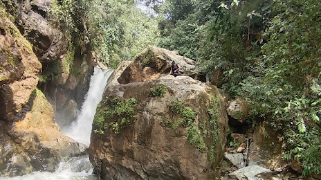
Where is located Río Pichindé
Río Pichindé — local attraction, which is located at Colombia and belongs to the category — -. Average visitor rating for this place — 4.7 (according to 6 ratings, information from open sources and relevant for 2022).
Exact location — Río Pichindé, marked on the map with a red marker.
You can get directions to Río Pichindé on the map from your location.
What else is interesting in Necoclí? You can see all the sights if you go to the city page.
Coordinates
Río Pichindé, Colombia coordinates in decimal format: latitude — 8.426792094093692, longitude — -76.78497715461558. When converted to degrees, minutes, seconds Río Pichindé has the following coordinates: 8°25′36.45 north latitude and -76°47′5.92 east longitude.
Nearby cities
The largest cities that are located nearby:
- Monteria — 105 km
- Sincelejo — 180 km
- Magangué — 240 km
- Cartagena — 259 km
- Bello — 268 km
- Medellín — 273 km
- Itagüi — 281 km
- Envigado — 282 km
- San Miguelito
 (Panama) — 303 km
 - Panama (Panama) — 304 km
- Malambo — 347 km
- Soledad — 352 km
- Barranquilla — 355 km
- Barrancabermeja — 356 km
- Manizales — 397 km
- Dos Quebradas — 416 km
- Pereira — 417 km
- Cartago — 418 km
- Santa Marta — 419 km
Distance to the capital
Distance to the capital (Bogota) is about — 521 km.