 Bel-Ha
San Jose El Alto
El Porvenir
Nueva Palestina
Santa Lucía
Chemax
La Morita
Temoac
Zacualpan
Bel-Ha
San Jose El Alto
El Porvenir
Nueva Palestina
Santa Lucía
Chemax
La Morita
Temoac
Zacualpan
Club Campestre La Pila on the map, Ciudad Constitución, Mexico
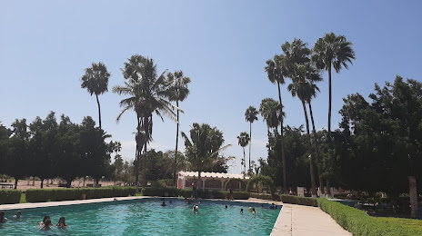
Photo
Where is located Club Campestre La Pila
Club Campestre La Pila — local attraction, which is located at Comondú, Baja California Sur, Mexico and belongs to the category — water park. Average visitor rating for this place — 4.4 (according to 84 ratings, information from open sources and relevant for 2022).
Exact location — Club Campestre La Pila, marked on the map with a red marker.
You can get directions to Club Campestre La Pila on the map from your location.
What else is interesting in Ciudad Constitución? You can see all the sights if you go to the city page.
Coordinates
Club Campestre La Pila, Mexico coordinates in decimal format: latitude — 25.017880534033818, longitude — -111.67589027544466. When converted to degrees, minutes, seconds Club Campestre La Pila has the following coordinates: 25°1′4.37 north latitude and -111°40′33.2 east longitude.
Nearby cities
The largest cities that are located nearby:
- La Paz — 168 km
- Los Mochis — 279 km
- Navojoa — 313 km
- Ciudad Obregón — 319 km
- Guaymas — 327 km
- Hermosillo — 451 km
- Mazatlán — 569 km
- Chihuahua — 673 km
- Delicias — 697 km
- Nogales
 (United States) — 700 km
 - Durango — 716 km
- Tucson (United States) — 797 km
- Tepic — 798 km
- Gómez Palacio — 817 km
- Puerto Vallarta — 824 km
- Torreón — 825 km
- Matamoros — 843 km
- San Luis Río Colorado — 870 km
- Ciudad Juarez — 885 km
Distance to the capital
Distance to the capital (Mexico City) is about — 1432 km.