 Warner Robins
Wantagh
Bethel
Misty Hill Farm
United States
Wakonda Beach (R33) Airport
Wilmington
Poland
Miami International Airport
Warner Robins
Wantagh
Bethel
Misty Hill Farm
United States
Wakonda Beach (R33) Airport
Wilmington
Poland
Miami International Airport
Seneca Regional Park on the map, North Potomac, United States
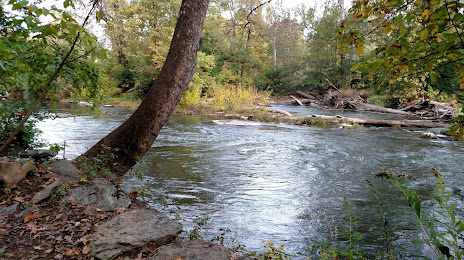
Photo
Where is located Seneca Regional Park
Seneca Regional Park — local attraction, which is located at 101 Seneca Rd, Great Falls, VA 22066, United States and belongs to the category — park. Average visitor rating for this place — 4.7 (according to 290 ratings, information from open sources and relevant for 2022).
Exact location — Seneca Regional Park, marked on the map with a red marker.
You can get directions to Seneca Regional Park on the map from your location.
What else is interesting in North Potomac? You can see all the sights if you go to the city page.
Coordinates
Seneca Regional Park, United States coordinates in decimal format: latitude — 39.24588349924516, longitude — -77.48359826713343. When converted to degrees, minutes, seconds Seneca Regional Park has the following coordinates: 39°14′45.18 north latitude and -77°29′0.95 east longitude.
Nearby cities
The largest cities that are located nearby:
- Alexandria — 36 km
- Baltimore — 57 km
- Richmond — 173 km
- Philadelphia — 199 km
- Allentown — 222 km
- Hampton — 242 km
- Norfolk — 262 km
- Chesapeake — 271 km
- Virginia Beach — 272 km
- Toms River — 274 km
- Pittsburgh — 276 km
- Edison — 285 km
- Elizabeth — 307 km
- Newark — 314 km
- Brooklyn — 324 km
- New York — 324 km
- Paterson — 325 km
- Yonkers — 345 km
- Durham — 374 km
Distance to the capital
Distance to the capital (Washington) is about — 54 km.