
 Maureville
Samoëns
Gréning
Toulouse
Volx
Goudet
Méhoncourt
Saint-Hymer
Pontcarré
Maureville
Samoëns
Gréning
Toulouse
Volx
Goudet
Méhoncourt
Saint-Hymer
Pontcarré
Paroisse St Germain on the map, Les Lilas, France
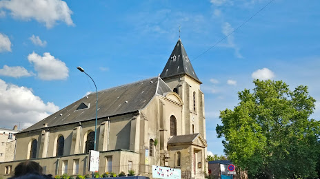
Photo
Where is located Paroisse St Germain
Paroisse St Germain — local attraction, which is located at 23 Rue de la Paix, 93500 Pantin, France and belongs to the category — parish. Average visitor rating for this place — 4.1 (according to 41 rating, information from open sources and relevant for 2022).
Exact location — Paroisse St Germain, marked on the map with a red marker.
You can get directions to Paroisse St Germain on the map from your location.
What else is interesting in Les Lilas? You can see all the sights if you go to the city page.
Coordinates
Paroisse St Germain, France coordinates in decimal format: latitude — 48.85946601564725, longitude — 2.341318925223864. When converted to degrees, minutes, seconds Paroisse St Germain has the following coordinates: 48°51′34.08 north latitude and 2°20′28.75 east longitude.
Nearby cities
The largest cities that are located nearby:
- Boulogne-Billancourt — 14 km
- Amiens — 112 km
- Rouen — 113 km
- Orléans — 115 km
- Reims — 124 km
- Le Havre — 179 km
- Le Mans — 191 km
- Lille — 198 km
- Caen — 204 km
- Tours — 210 km
- Charleroi
 (Belgium) — 221 km
 - Namur (Belgium) — 246 km
- Brussels (Belgium) — 256 km
- Eastbourne
 (United Kingdom) — 256 km
 - Dijon — 261 km
- Angers — 272 km
- Metz — 273 km
- Nancy — 276 km
- Antwerp (Belgium) — 293 km
Distance to the capital
Distance to the capital (Paris) is about — 1 km.