
 Gilserberg
Berlin
Bordesholm
Bechtolsheim
Aub
Triptis
Heppenheim
Biblis
Angermünde
Gilserberg
Berlin
Bordesholm
Bechtolsheim
Aub
Triptis
Heppenheim
Biblis
Angermünde
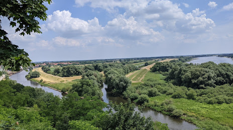
Mecklenburgisches Elbetal on the map, Boizenburg, Germany
Photo
Where is located Mecklenburgisches Elbetal
Mecklenburgisches Elbetal — local attraction, which is located at Germany and belongs to the category — nature reserve. Average visitor rating for this place — 4.5 (according to 1310 ratings, information from open sources and relevant for 2022).
Exact location — Mecklenburgisches Elbetal, marked on the map with a red marker.
You can get directions to Mecklenburgisches Elbetal on the map from your location.
What else is interesting in Boizenburg? You can see all the sights if you go to the city page.
Coordinates
Mecklenburgisches Elbetal, Germany coordinates in decimal format: latitude — 53.33434214999387, longitude — 11.038223925387404. When converted to degrees, minutes, seconds Mecklenburgisches Elbetal has the following coordinates: 53°20′3.63 north latitude and 11°2′17.61 east longitude.
Nearby cities
The largest cities that are located nearby:
- Wolfsburg — 106 km
- Kiel — 111 km
- Rostock — 119 km
- Brunswick — 124 km
- Hanover — 130 km
- Bremen — 132 km
- Salzgitter — 139 km
- Bremerhaven — 142 km
- Hildesheim — 145 km
- Magdeburg — 152 km
- Potsdam — 192 km
- Berlin — 205 km
- Göttingen — 211 km
- Bielefeld — 211 km
- Osnabrück — 218 km
- Odense
 (Denmark) — 225 km
 - Paderborn — 228 km
- Kassel — 244 km
- Szczecin
 (Poland) — 253 km
Distance to the capital
Distance to the capital (Berlin) is about — 183 km.