
 Gilserberg
Berlin
Bordesholm
Bechtolsheim
Aub
Triptis
Heppenheim
Biblis
Angermünde
Gilserberg
Berlin
Bordesholm
Bechtolsheim
Aub
Triptis
Heppenheim
Biblis
Angermünde
St. Laurentius-Kirche on the map, Warendorf, Germany
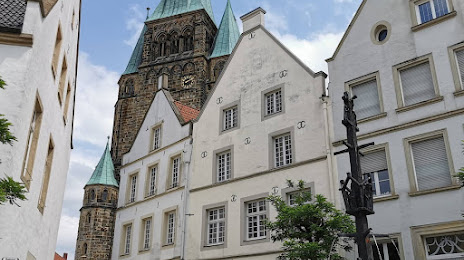
Photo
Where is located St. Laurentius-Kirche
St. Laurentius-Kirche — local attraction, which is located at Kirchstraße, 48231 Warendorf, Germany and belongs to the category — catholic church. Average visitor rating for this place — 4.4 (according to 84 ratings, information from open sources and relevant for 2022).
Exact location — St. Laurentius-Kirche, marked on the map with a red marker.
You can get directions to St. Laurentius-Kirche on the map from your location.
What else is interesting in Warendorf? You can see all the sights if you go to the city page.
Coordinates
St. Laurentius-Kirche, Germany coordinates in decimal format: latitude — 51.952523424216835, longitude — 7.991576125335811. When converted to degrees, minutes, seconds St. Laurentius-Kirche has the following coordinates: 51°57′9.08 north latitude and 7°59′29.67 east longitude.
Nearby cities
The largest cities that are located nearby:
- Münster — 25 km
- Hamm — 33 km
- Osnabrück — 36 km
- Bielefeld — 38 km
- Paderborn — 59 km
- Dortmund — 61 km
- Recklinghausen — 66 km
- Herne — 71 km
- Witten — 71 km
- Hagen — 74 km
- Bochum — 75 km
- Gelsenkirchen — 79 km
- Enschede
 (Netherlands) — 80 km
 - Bottrop — 86 km
- Essen — 87 km
- Oberhausen — 93 km
- Mülheim — 97 km
- Wuppertal — 97 km
- Remscheid — 102 km
Distance to the capital
Distance to the capital (Berlin) is about — 374 km.