
 Gilserberg
Berlin
Bordesholm
Bechtolsheim
Aub
Triptis
Heppenheim
Biblis
Angermünde
Gilserberg
Berlin
Bordesholm
Bechtolsheim
Aub
Triptis
Heppenheim
Biblis
Angermünde
Forstbotanischer Garten Tharandt on the map, Freital, Germany
Photo
Where is located Forstbotanischer Garten Tharandt
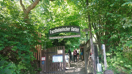
Forstbotanischer Garten Tharandt — local attraction, which is located at Am Forstgarten 1, 01737 Tharandt, Germany and belongs to the category — botanical garden. Average visitor rating for this place — 4.7 (according to 666 ratings, information from open sources and relevant for 2022).
Exact location — Forstbotanischer Garten Tharandt, marked on the map with a red marker.
You can get directions to Forstbotanischer Garten Tharandt on the map from your location.
What else is interesting in Freital? You can see all the sights if you go to the city page.
Coordinates
Forstbotanischer Garten Tharandt, Germany coordinates in decimal format: latitude — 50.980278583210904, longitude — 13.566777225300132. When converted to degrees, minutes, seconds Forstbotanischer Garten Tharandt has the following coordinates: 50°58′49 north latitude and 13°34′0.4 east longitude.
Nearby cities
The largest cities that are located nearby:
- Dresden — 8 km
- Chemnitz — 54 km
- Cottbus — 96 km
- Leipzig — 96 km
- Gera — 110 km
- Prague
 (Czech Republic) — 117 km
 - Pilsen (Czech Republic) — 141 km
- Potsdam — 159 km
- Zielona Gora
 (Poland) — 163 km
 - Berlin — 167 km
- Legnica (Poland) — 175 km
- Erfurt — 182 km
- Magdeburg — 185 km
- Walbrzych (Poland) — 186 km
- Gorzów Wielkopolski (Poland) — 219 km
- Wrocław (Poland) — 235 km
- Erlangen — 245 km
- Regensburg — 247 km
- Wolfsburg — 249 km
Distance to the capital
Distance to the capital (Berlin) is about — 172 km.