
 Józefów nad Wisłą
Gorzyce Wielkie
Rogówek
Sromowce Niżne
Wyszków County
Kruszewo
Jantar
Sady Górne
Nagoszewo
Józefów nad Wisłą
Gorzyce Wielkie
Rogówek
Sromowce Niżne
Wyszków County
Kruszewo
Jantar
Sady Górne
Nagoszewo
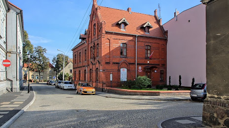
Muzeum w Gostyniu on the map, Gostyn, Poland
Photo
Where is located Muzeum w Gostyniu
Muzeum w Gostyniu — local attraction, which is located at Kościelna 5, 63-800 Gostyń, Poland and belongs to the category — museum. Average visitor rating for this place — 4.7 (according to 43 ratings, information from open sources and relevant for 2022).
Exact location — Muzeum w Gostyniu, marked on the map with a red marker.
You can get directions to Muzeum w Gostyniu on the map from your location.
What else is interesting in Gostyn? You can see all the sights if you go to the city page.
Coordinates
Muzeum w Gostyniu, Poland coordinates in decimal format: latitude — 51.878654375210544, longitude — 17.017769325333052. When converted to degrees, minutes, seconds Muzeum w Gostyniu has the following coordinates: 51°52′43.16 north latitude and 17°1′3.97 east longitude.
Nearby cities
The largest cities that are located nearby:
- Poznań — 59 km
- Kalisz — 74 km
- Wrocław — 85 km
- Legnica — 95 km
- Zielona Gora — 103 km
- Walbrzych — 131 km
- Opole — 148 km
- Gorzów Wielkopolski — 152 km
- Bydgoszcz — 153 km
- Wloclawek — 162 km
- Torun — 164 km
- Łódź — 168 km
- Cottbus
 (Germany) — 184 km
 - Częstochowa — 189 km
- Plock — 196 km
- Gliwice — 211 km
- Zabrze — 213 km
- Bytom — 216 km
- Ruda Slaska — 222 km
Distance to the capital
Distance to the capital (Warsaw) is about — 276 km.