
 Józefów nad Wisłą
Gorzyce Wielkie
Rogówek
Sromowce Niżne
Wyszków County
Kruszewo
Jantar
Sady Górne
Nagoszewo
Józefów nad Wisłą
Gorzyce Wielkie
Rogówek
Sromowce Niżne
Wyszków County
Kruszewo
Jantar
Sady Górne
Nagoszewo
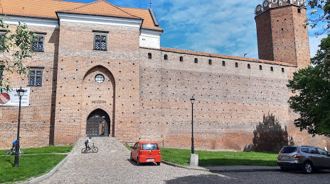
The Royal Castle in Łęczyca on the map, Leczyca, Poland
Photo
Where is located The Royal Castle in Łęczyca
The Royal Castle in Łęczyca — local attraction, which is located at Zamkowa 1, 99-100 Łęczyca, Poland and belongs to the category — medieval castle. Average visitor rating for this place — 4.3 (according to 2124 ratings, information from open sources and relevant for 2022).
Exact location — The Royal Castle in Łęczyca, marked on the map with a red marker.
You can get directions to The Royal Castle in Łęczyca on the map from your location.
What else is interesting in Leczyca? You can see all the sights if you go to the city page.
Coordinates
The Royal Castle in Łęczyca, Poland coordinates in decimal format: latitude — 52.05910769501435, longitude — 19.203683825339805. When converted to degrees, minutes, seconds The Royal Castle in Łęczyca has the following coordinates: 52°3′32.79 north latitude and 19°12′13.26 east longitude.
Nearby cities
The largest cities that are located nearby:
- Łódź — 38 km
- Plock — 64 km
- Wloclawek — 66 km
- Kalisz — 83 km
- Torun — 113 km
- Częstochowa — 138 km
- Bydgoszcz — 142 km
- Radom — 153 km
- Poznań — 158 km
- Kielce — 165 km
- Opole — 177 km
- Wrocław — 183 km
- Bytom — 190 km
- Dabrowa Gornicza — 192 km
- Zabrze — 194 km
- Chorzow — 196 km
- Sosnowiec — 196 km
- Gliwice — 199 km
- Katowice — 199 km
Distance to the capital
Distance to the capital (Warsaw) is about — 125 km.