
 Józefów nad Wisłą
Gorzyce Wielkie
Rogówek
Sromowce Niżne
Wyszków County
Kruszewo
Jantar
Sady Górne
Nagoszewo
Józefów nad Wisłą
Gorzyce Wielkie
Rogówek
Sromowce Niżne
Wyszków County
Kruszewo
Jantar
Sady Górne
Nagoszewo
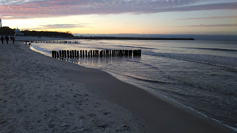
Plaża Wschodnia w Ustce on the map, Ustka, Poland
Photo
Where is located Plaża Wschodnia w Ustce
Plaża Wschodnia w Ustce — local attraction, which is located at no data and belongs to the category — -. Average visitor rating for this place — 4.6 (according to 9365 ratings, information from open sources and relevant for 2022).
Exact location — Plaża Wschodnia w Ustce, marked on the map with a red marker.
You can get directions to Plaża Wschodnia w Ustce on the map from your location.
What else is interesting in Ustka? You can see all the sights if you go to the city page.
Coordinates
Plaża Wschodnia w Ustce, Poland coordinates in decimal format: latitude — 54.58745052957112, longitude — 16.85861683500765. When converted to degrees, minutes, seconds Plaża Wschodnia w Ustce has the following coordinates: 54°35′14.82 north latitude and 16°51′31.02 east longitude.
Nearby cities
The largest cities that are located nearby:
- Koszalin — 62 km
- Gdynia — 107 km
- Gdańsk — 118 km
- Elblag — 171 km
- Bydgoszcz — 178 km
- Szczecin — 198 km
- Torun — 208 km
- Gorzów Wielkopolski — 231 km
- Kaliningrad
 (Russia) — 234 km
 - Poznań — 240 km
- Olsztyn — 252 km
- Wloclawek — 260 km
- Malmö
 (Sweden) — 266 km
 - Copenhagen
 (Denmark) — 294 km
 - Klaipėda
 (Lithuania) — 294 km
 - Plock — 295 km
- Zielona Gora — 307 km
- Rostock
 (Germany) — 314 km
 - Kalisz — 322 km
Distance to the capital
Distance to the capital (Warsaw) is about — 380 km.