
 Gilserberg
Berlin
Bordesholm
Bechtolsheim
Aub
Triptis
Heppenheim
Biblis
Angermünde
Gilserberg
Berlin
Bordesholm
Bechtolsheim
Aub
Triptis
Heppenheim
Biblis
Angermünde
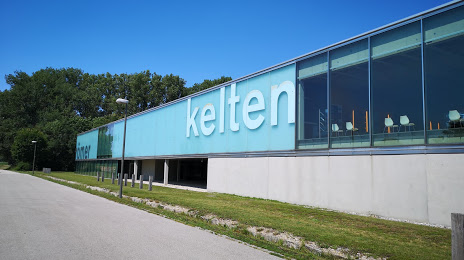
Kelten- & Römermuseum Manching on the map, Manching, Germany
Photo
Where is located Kelten- & Römermuseum Manching
Kelten- & Römermuseum Manching — local attraction, which is located at Im Erlet 2, 85077 Manching, Germany and belongs to the category — museum. Average visitor rating for this place — 4.3 (according to 281 rating, information from open sources and relevant for 2022).
Exact location — Kelten- & Römermuseum Manching, marked on the map with a red marker.
You can get directions to Kelten- & Römermuseum Manching on the map from your location.
What else is interesting in Manching? You can see all the sights if you go to the city page.
Coordinates
Kelten- & Römermuseum Manching, Germany coordinates in decimal format: latitude — 48.71281312267269, longitude — 11.492348625218654. When converted to degrees, minutes, seconds Kelten- & Römermuseum Manching has the following coordinates: 48°42′46.13 north latitude and 11°29′32.46 east longitude.
Nearby cities
The largest cities that are located nearby:
- Ingolstadt — 7 km
- Regensburg — 55 km
- Augsburg — 58 km
- Munich — 65 km
- Nuremberg — 87 km
- Fürth — 91 km
- Erlangen — 102 km
- Ulm — 116 km
- Salzburg
 (Austria) — 153 km
 - Innsbruck (Austria) — 160 km
- Würzburg — 162 km
- Stuttgart — 169 km
- Reutlingen — 169 km
- Heilbronn — 172 km
- Pilsen
 (Czech Republic) — 175 km
 - Pforzheim — 204 km
- Linz (Austria) — 210 km
- Heidelberg — 217 km
- Karlsruhe — 226 km
Distance to the capital
Distance to the capital (Berlin) is about — 444 km.