
 Józefów nad Wisłą
Gorzyce Wielkie
Rogówek
Sromowce Niżne
Wyszków County
Kruszewo
Jantar
Sady Górne
Nagoszewo
Józefów nad Wisłą
Gorzyce Wielkie
Rogówek
Sromowce Niżne
Wyszków County
Kruszewo
Jantar
Sady Górne
Nagoszewo
Museum of the Busko Region (Muzeum Ziemi Buskiej w Busku-Zdroju) on the map, Busko-Zdrój, Poland
Photo
Where is located Museum of the Busko Region (Muzeum Ziemi Buskiej w Busku-Zdroju)
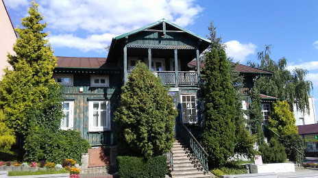
Museum of the Busko Region (Muzeum Ziemi Buskiej w Busku-Zdroju) — local attraction, which is located at Aleja Adama Mickiewicza 7, 28-100 Busko-Zdrój, Poland and belongs to the category — museum. Average visitor rating for this place — 4.2 (according to 49 ratings, information from open sources and relevant for 2022).
Exact location — Museum of the Busko Region (Muzeum Ziemi Buskiej w Busku-Zdroju), marked on the map with a red marker.
You can get directions to Museum of the Busko Region (Muzeum Ziemi Buskiej w Busku-Zdroju) on the map from your location.
What else is interesting in Busko-Zdrój? You can see all the sights if you go to the city page.
Coordinates
Museum of the Busko Region (Muzeum Ziemi Buskiej w Busku-Zdroju), Poland coordinates in decimal format: latitude — 50.46912294971139, longitude — 20.719877325281487. When converted to degrees, minutes, seconds Museum of the Busko Region (Muzeum Ziemi Buskiej w Busku-Zdroju) has the following coordinates: 50°28′8.84 north latitude and 20°43′11.56 east longitude.
Nearby cities
The largest cities that are located nearby:
- Kielce — 44 km
- Tarnow — 54 km
- Kraków — 71 km
- Rzeszow — 103 km
- Radom — 107 km
- Dabrowa Gornicza — 109 km
- Sosnowiec — 116 km
- Częstochowa — 118 km
- Katowice — 122 km
- Chorzow — 126 km
- Bytom — 128 km
- Ruda Slaska — 134 km
- Zabrze — 137 km
- Bielsko-Biala — 138 km
- Gliwice — 146 km
- Lublin — 154 km
- Rybnik — 159 km
- Łódź — 167 km
- Ostrava
 (Czech Republic) — 189 km
Distance to the capital
Distance to the capital (Warsaw) is about — 197 km.