
 Józefów nad Wisłą
Gorzyce Wielkie
Rogówek
Sromowce Niżne
Wyszków County
Kruszewo
Jantar
Sady Górne
Nagoszewo
Józefów nad Wisłą
Gorzyce Wielkie
Rogówek
Sromowce Niżne
Wyszków County
Kruszewo
Jantar
Sady Górne
Nagoszewo
Church of Sts. Stanislaus on the map, Skierniewice, Poland
Photo
Where is located Church of Sts. Stanislaus
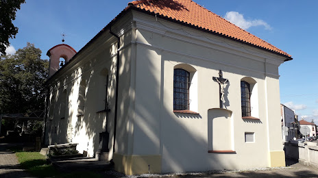
Church of Sts. Stanislaus — local attraction, which is located at świętego Stanisława 1, 96-100 Skierniewice, Poland and belongs to the category — catholic church. Average visitor rating for this place — 4.5 (according to 0 ratings, information from open sources and relevant for 2022).
Exact location — Church of Sts. Stanislaus, marked on the map with a red marker.
You can get directions to Church of Sts. Stanislaus on the map from your location.
What else is interesting in Skierniewice? You can see all the sights if you go to the city page.
Coordinates
Church of Sts. Stanislaus, Poland coordinates in decimal format: latitude — 51.954206825334104, longitude — 20.145437625335855. When converted to degrees, minutes, seconds Church of Sts. Stanislaus has the following coordinates: 51°57′15.14 north latitude and 20°8′43.58 east longitude.
Nearby cities
The largest cities that are located nearby:
- Łódź — 53 km
- Plock — 72 km
- Radom — 92 km
- Wloclawek — 106 km
- Kielce — 125 km
- Kalisz — 143 km
- Częstochowa — 146 km
- Torun — 156 km
- Lublin — 184 km
- Bydgoszcz — 192 km
- Dabrowa Gornicza — 193 km
- Bytom — 198 km
- Sosnowiec — 199 km
- Chorzow — 202 km
- Olsztyn — 203 km
- Katowice — 203 km
- Zabrze — 205 km
- Ruda Slaska — 209 km
- Kraków — 210 km
Distance to the capital
Distance to the capital (Warsaw) is about — 67 km.