
 Gilserberg
Berlin
Bordesholm
Bechtolsheim
Aub
Triptis
Heppenheim
Biblis
Angermünde
Gilserberg
Berlin
Bordesholm
Bechtolsheim
Aub
Triptis
Heppenheim
Biblis
Angermünde
Treetop Walk Saarschleife on the map, Mettlach, Germany
Photo
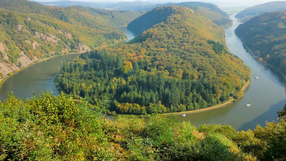
Where is located Treetop Walk Saarschleife
Treetop Walk Saarschleife — local attraction, which is located at Cloef-Atrium, 66693 Mettlach, Germany and belongs to the category — water gap. Average visitor rating for this place — 4.6 (according to 4813 ratings, information from open sources and relevant for 2022).
Exact location — Treetop Walk Saarschleife, marked on the map with a red marker.
You can get directions to Treetop Walk Saarschleife on the map from your location.
What else is interesting in Mettlach? You can see all the sights if you go to the city page.
Coordinates
Treetop Walk Saarschleife, Germany coordinates in decimal format: latitude — 49.50276142593864, longitude — 6.53965077524673. When converted to degrees, minutes, seconds Treetop Walk Saarschleife has the following coordinates: 49°30′9.94 north latitude and 6°32′22.74 east longitude.
Nearby cities
The largest cities that are located nearby:
- Trier — 28 km
- Saarbrücken — 41 km
- Metz
 (France) — 51 km
 - Nancy (France) — 93 km
- Koblenz — 119 km
- Mainz — 130 km
- Strasbourg (France) — 133 km
- Ludwigshafen — 134 km
- Wiesbaden — 134 km
- Mannheim — 135 km
- Bonn — 142 km
- Karlsruhe — 143 km
- Liège
 (Belgium) — 144 km
 - Aachen — 146 km
- Heidelberg — 151 km
- Darmstadt — 153 km
- Namur (Belgium) — 161 km
- Cologne — 162 km
- Maastricht
 (Netherlands) — 162 km
Distance to the capital
Distance to the capital (Berlin) is about — 586 km.