
 Józefów nad Wisłą
Gorzyce Wielkie
Rogówek
Sromowce Niżne
Wyszków County
Kruszewo
Jantar
Sady Górne
Nagoszewo
Józefów nad Wisłą
Gorzyce Wielkie
Rogówek
Sromowce Niżne
Wyszków County
Kruszewo
Jantar
Sady Górne
Nagoszewo
Plaża Miejska w Augustowie on the map, Augustow, Poland
Photo
Where is located Plaża Miejska w Augustowie
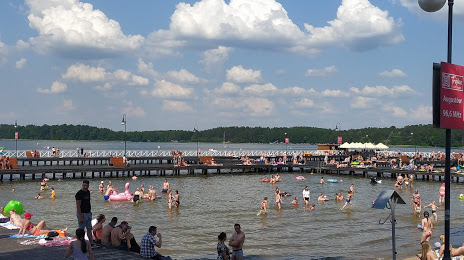
Plaża Miejska w Augustowie — local attraction, which is located at no data and belongs to the category — -. Average visitor rating for this place — 4.6 (according to 4212 ratings, information from open sources and relevant for 2022).
Exact location — Plaża Miejska w Augustowie, marked on the map with a red marker.
You can get directions to Plaża Miejska w Augustowie on the map from your location.
What else is interesting in Augustow? You can see all the sights if you go to the city page.
Coordinates
Plaża Miejska w Augustowie, Poland coordinates in decimal format: latitude — 53.85381190469752, longitude — 22.98526411465665. When converted to degrees, minutes, seconds Plaża Miejska w Augustowie has the following coordinates: 53°51′13.72 north latitude and 22°59′6.95 east longitude.
Nearby cities
The largest cities that are located nearby:
- Bialystok — 80 km
- Kaunas
 (Lithuania) — 131 km
 - Olsztyn — 163 km
- Vilnius (Lithuania) — 174 km
- Kaliningrad
 (Russia) — 185 km
 - Brest
 (Belarus) — 200 km
 - Baranovichi (Belarus) — 216 km
- Panevėžys (Lithuania) — 226 km
- Šiauliai (Lithuania) — 232 km
- Elblag — 234 km
- Klaipėda (Lithuania) — 235 km
- Maladzyechna (Belarus) — 255 km
- Plock — 263 km
- Pinsk (Belarus) — 283 km
- Gdańsk — 285 km
- Lublin — 289 km
- Wloclawek — 294 km
- Gdynia — 295 km
- Radom — 298 km
Distance to the capital
Distance to the capital (Warsaw) is about — 224 km.