
 Józefów nad Wisłą
Gorzyce Wielkie
Rogówek
Sromowce Niżne
Wyszków County
Kruszewo
Jantar
Sady Górne
Nagoszewo
Józefów nad Wisłą
Gorzyce Wielkie
Rogówek
Sromowce Niżne
Wyszków County
Kruszewo
Jantar
Sady Górne
Nagoszewo
Kościół Rzymskokatolicki Sanktuarium Św. Jakuba Apostoła on the map, Brzeg, Poland
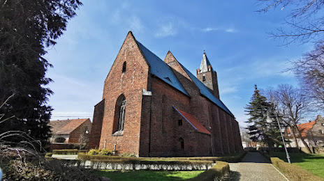
Photo
Where is located Kościół Rzymskokatolicki Sanktuarium Św. Jakuba Apostoła
Kościół Rzymskokatolicki Sanktuarium Św. Jakuba Apostoła — local attraction, which is located at 49-353 Małujowice, Poland and belongs to the category — catholic church. Average visitor rating for this place — 4.4 (according to 87 ratings, information from open sources and relevant for 2022).
Exact location — Kościół Rzymskokatolicki Sanktuarium Św. Jakuba Apostoła, marked on the map with a red marker.
You can get directions to Kościół Rzymskokatolicki Sanktuarium Św. Jakuba Apostoła on the map from your location.
What else is interesting in Brzeg? You can see all the sights if you go to the city page.
Coordinates
Kościół Rzymskokatolicki Sanktuarium Św. Jakuba Apostoła, Poland coordinates in decimal format: latitude — 50.85478645799348, longitude — 17.40584624890414. When converted to degrees, minutes, seconds Kościół Rzymskokatolicki Sanktuarium Św. Jakuba Apostoła has the following coordinates: 50°51′17.23 north latitude and 17°24′21.05 east longitude.
Nearby cities
The largest cities that are located nearby:
- Opole — 38 km
- Wrocław — 40 km
- Walbrzych — 83 km
- Legnica — 99 km
- Gliwice — 106 km
- Kalisz — 109 km
- Zabrze — 110 km
- Rybnik — 114 km
- Częstochowa — 116 km
- Bytom — 117 km
- Ruda Slaska — 119 km
- Chorzow — 122 km
- Ostrava
 (Czech Republic) — 128 km
 - Katowice — 128 km
- Sosnowiec — 132 km
- Dabrowa Gornicza — 136 km
- Olomouc (Czech Republic) — 141 km
- Bielsko-Biala — 161 km
- Łódź — 169 km
Distance to the capital
Distance to the capital (Warsaw) is about — 293 km.