
 Józefów nad Wisłą
Gorzyce Wielkie
Rogówek
Sromowce Niżne
Wyszków County
Kruszewo
Jantar
Sady Górne
Nagoszewo
Józefów nad Wisłą
Gorzyce Wielkie
Rogówek
Sromowce Niżne
Wyszków County
Kruszewo
Jantar
Sady Górne
Nagoszewo
Zamek Carolath (Ruiny Zamku Karolat w Siedlisku) on the map, Nowa Sol, Poland
Photo
Where is located Zamek Carolath (Ruiny Zamku Karolat w Siedlisku)
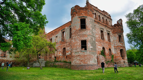
Zamek Carolath (Ruiny Zamku Karolat w Siedlisku) — local attraction, which is located at Plac Zamkowy 9, 67-112 Siedlisko, Poland and belongs to the category — castle. Average visitor rating for this place — 4.3 (according to 373 ratings, information from open sources and relevant for 2022).
Exact location — Zamek Carolath (Ruiny Zamku Karolat w Siedlisku), marked on the map with a red marker.
You can get directions to Zamek Carolath (Ruiny Zamku Karolat w Siedlisku) on the map from your location.
What else is interesting in Nowa Sol? You can see all the sights if you go to the city page.
Coordinates
Zamek Carolath (Ruiny Zamku Karolat w Siedlisku), Poland coordinates in decimal format: latitude — 51.7664493008667, longitude — 15.80497732532892. When converted to degrees, minutes, seconds Zamek Carolath (Ruiny Zamku Karolat w Siedlisku) has the following coordinates: 51°45′59.22 north latitude and 15°48′17.92 east longitude.
Nearby cities
The largest cities that are located nearby:
- Zielona Gora — 21 km
- Legnica — 73 km
- Cottbus
 (Germany) — 95 km
 - Poznań — 105 km
- Gorzów Wielkopolski — 108 km
- Walbrzych — 119 km
- Wrocław — 120 km
- Dresden (Germany) — 161 km
- Kalisz — 162 km
- Berlin (Germany) — 174 km
- Berlin (Germany) — 175 km
- Potsdam (Germany) — 190 km
- Szczecin — 195 km
- Opole — 199 km
- Bydgoszcz — 211 km
- Prague
 (Czech Republic) — 212 km
 - Chemnitz (Germany) — 223 km
- Torun — 234 km
- Leipzig (Germany) — 237 km
Distance to the capital
Distance to the capital (Warsaw) is about — 360 km.