
 Gilserberg
Berlin
Bordesholm
Bechtolsheim
Aub
Triptis
Heppenheim
Biblis
Angermünde
Gilserberg
Berlin
Bordesholm
Bechtolsheim
Aub
Triptis
Heppenheim
Biblis
Angermünde
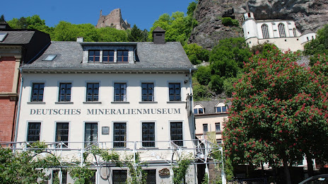
Deutsches Mineralienmuseum on the map, Idar-Oberstein, Germany
Photo
Where is located Deutsches Mineralienmuseum
Deutsches Mineralienmuseum — local attraction, which is located at Hauptstraße 436, 55743 Idar-Oberstein, Germany and belongs to the category — museum. Average visitor rating for this place — 4.4 (according to 240 ratings, information from open sources and relevant for 2022).
Exact location — Deutsches Mineralienmuseum, marked on the map with a red marker.
You can get directions to Deutsches Mineralienmuseum on the map from your location.
What else is interesting in Idar-Oberstein? You can see all the sights if you go to the city page.
Coordinates
Deutsches Mineralienmuseum, Germany coordinates in decimal format: latitude — 49.70490885568806, longitude — 7.328352925253924. When converted to degrees, minutes, seconds Deutsches Mineralienmuseum has the following coordinates: 49°42′17.67 north latitude and 7°19′42.07 east longitude.
Nearby cities
The largest cities that are located nearby:
- Trier — 48 km
- Saarbrücken — 57 km
- Mainz — 74 km
- Koblenz — 74 km
- Wiesbaden — 77 km
- Ludwigshafen — 86 km
- Mannheim — 87 km
- Darmstadt — 97 km
- Heidelberg — 104 km
- Metz
 (France) — 105 km
 - Frankfurt — 107 km
- Karlsruhe — 112 km
- Offenbach — 112 km
- Bonn — 114 km
- Strasbourg (France) — 130 km
- Pforzheim — 136 km
- Cologne — 137 km
- Siegen — 139 km
- Nancy (France) — 140 km
Distance to the capital
Distance to the capital (Berlin) is about — 527 km.