
 Pfäffikon
Le Landeron
Unterägeri
Dachsen
Andermatt
Lungern
Croglio
Vogorno
Opfikon
Pfäffikon
Le Landeron
Unterägeri
Dachsen
Andermatt
Lungern
Croglio
Vogorno
Opfikon
Albis Pass on the map, Horgen, Switzerland
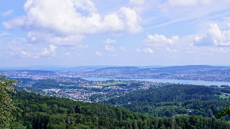
Photo
Where is located Albis Pass
Albis Pass — local attraction, which is located at 793 m and belongs to the category — -. Average visitor rating for this place — 4.5 (according to 38 ratings, information from open sources and relevant for 2022).
Exact location — Albis Pass, marked on the map with a red marker.
You can get directions to Albis Pass on the map from your location.
What else is interesting in Horgen? You can see all the sights if you go to the city page.
Coordinates
Albis Pass, Switzerland coordinates in decimal format: latitude — 47.27583606635358, longitude — 8.52035489930703. When converted to degrees, minutes, seconds Albis Pass has the following coordinates: 47°16′33.01 north latitude and 8°31′13.28 east longitude.
Nearby cities
The largest cities that are located nearby:
- Zurich — 13 km
- Basel — 82 km
- Freiburg
 (Germany) — 99 km
 - Mulhouse
 (France) — 108 km
 - Reutlingen (Germany) — 145 km
- Strasbourg (France) — 158 km
- Ulm (Germany) — 163 km
- Lausanne — 170 km
- Stuttgart (Germany) — 173 km
- Pforzheim (Germany) — 181 km
- Bergamo
 (Italy) — 191 km
 - Monza (Italy) — 192 km
- Besançon (France) — 193 km
- Karlsruhe (Germany) — 194 km
- Novara (Italy) — 200 km
- Milan (Italy) — 203 km
- Augsburg (Germany) — 209 km
- Innsbruck
 (Austria) — 211 km
 - Heilbronn (Germany) — 213 km
Distance to the capital
Distance to the capital (Bern) is about — 89 km.