
 Józefów nad Wisłą
Gorzyce Wielkie
Rogówek
Sromowce Niżne
Wyszków County
Kruszewo
Jantar
Sady Górne
Nagoszewo
Józefów nad Wisłą
Gorzyce Wielkie
Rogówek
Sromowce Niżne
Wyszków County
Kruszewo
Jantar
Sady Górne
Nagoszewo
Klasztor Węgrów on the map, Wegrow, Poland
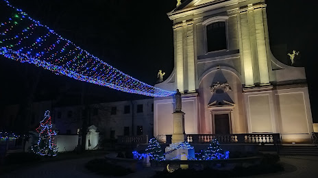
Photo
Where is located Klasztor Węgrów
Klasztor Węgrów — local attraction, which is located at Tadeusza Kościuszki 27a, 07-100 Węgrów, Poland and belongs to the category — monastery. Average visitor rating for this place — 4.6 (according to 5 ratings, information from open sources and relevant for 2022).
Exact location — Klasztor Węgrów, marked on the map with a red marker.
You can get directions to Klasztor Węgrów on the map from your location.
What else is interesting in Wegrow? You can see all the sights if you go to the city page.
Coordinates
Klasztor Węgrów, Poland coordinates in decimal format: latitude — 52.39904462150065, longitude — 22.02354132535241. When converted to degrees, minutes, seconds Klasztor Węgrów has the following coordinates: 52°23′56.56 north latitude and 22°1′24.75 east longitude.
Nearby cities
The largest cities that are located nearby:
- Bialystok — 111 km
- Brest
 (Belarus) — 121 km
 - Radom — 125 km
- Lublin — 133 km
- Plock — 156 km
- Olsztyn — 183 km
- Łódź — 189 km
- Kielce — 195 km
- Wloclawek — 200 km
- Torun — 237 km
- Elblag — 258 km
- Rzeszow — 261 km
- Częstochowa — 268 km
- Kaliningrad
 (Russia) — 274 km
 - Tarnow — 274 km
- Baranovichi (Belarus) — 277 km
- Pinsk (Belarus) — 277 km
- Bydgoszcz — 278 km
- Kalisz — 278 km
Distance to the capital
Distance to the capital (Warsaw) is about — 71 km.