
 Józefów nad Wisłą
Gorzyce Wielkie
Rogówek
Sromowce Niżne
Wyszków County
Kruszewo
Jantar
Sady Górne
Nagoszewo
Józefów nad Wisłą
Gorzyce Wielkie
Rogówek
Sromowce Niżne
Wyszków County
Kruszewo
Jantar
Sady Górne
Nagoszewo
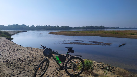
The beach at the mouth of Swider on the map, Otwock, Poland
Photo
Where is located The beach at the mouth of Swider
The beach at the mouth of Swider — local attraction, which is located at Świdry Wielkie, Poland and belongs to the category — scenic spot. Average visitor rating for this place — 4.7 (according to 503 ratings, information from open sources and relevant for 2022).
Exact location — The beach at the mouth of Swider, marked on the map with a red marker.
You can get directions to The beach at the mouth of Swider on the map from your location.
What else is interesting in Otwock? You can see all the sights if you go to the city page.
Coordinates
The beach at the mouth of Swider, Poland coordinates in decimal format: latitude — 52.11527854639201, longitude — 21.28742598736579. When converted to degrees, minutes, seconds The beach at the mouth of Swider has the following coordinates: 52°6′55 north latitude and 21°17′14.73 east longitude.
Nearby cities
The largest cities that are located nearby:
- Radom — 78 km
- Plock — 115 km
- Łódź — 129 km
- Lublin — 131 km
- Kielce — 144 km
- Wloclawek — 159 km
- Brest
 (Belarus) — 168 km
 - Bialystok — 170 km
- Olsztyn — 192 km
- Torun — 204 km
- Częstochowa — 207 km
- Kalisz — 221 km
- Tarnow — 232 km
- Rzeszow — 234 km
- Bydgoszcz — 243 km
- Kraków — 244 km
- Dabrowa Gornicza — 245 km
- Sosnowiec — 252 km
- Bytom — 255 km
Distance to the capital
Distance to the capital (Warsaw) is about — 23 km.