
 Józefów nad Wisłą
Gorzyce Wielkie
Rogówek
Sromowce Niżne
Wyszków County
Kruszewo
Jantar
Sady Górne
Nagoszewo
Józefów nad Wisłą
Gorzyce Wielkie
Rogówek
Sromowce Niżne
Wyszków County
Kruszewo
Jantar
Sady Górne
Nagoszewo
Magiczne Ogrody on the map, Pulawy, Poland
Photo
Where is located Magiczne Ogrody
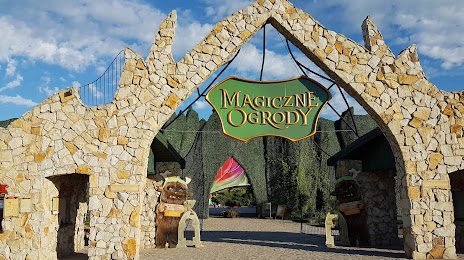
Magiczne Ogrody — local attraction, which is located at Trzcianki 92, 24-123, Poland and belongs to the category — garden. Average visitor rating for this place — 4.7 (according to 9200 ratings, information from open sources and relevant for 2022).
Exact location — Magiczne Ogrody, marked on the map with a red marker.
You can get directions to Magiczne Ogrody on the map from your location.
What else is interesting in Pulawy? You can see all the sights if you go to the city page.
Coordinates
Magiczne Ogrody, Poland coordinates in decimal format: latitude — 51.365254535988086, longitude — 21.910174025314152. When converted to degrees, minutes, seconds Magiczne Ogrody has the following coordinates: 51°21′54.92 north latitude and 21°54′36.63 east longitude.
Nearby cities
The largest cities that are located nearby:
- Lublin — 46 km
- Radom — 57 km
- Kielce — 112 km
- Brest
 (Belarus) — 142 km
 - Rzeszow — 152 km
- Tarnow — 170 km
- Łódź — 176 km
- Plock — 197 km
- Bialystok — 206 km
- Kraków — 207 km
- Częstochowa — 210 km
- Dabrowa Gornicza — 230 km
- Wloclawek — 238 km
- Sosnowiec — 238 km
- Katowice — 244 km
- Bytom — 246 km
- Chorzow — 246 km
- Ruda Slaska — 255 km
- Zabrze — 255 km
Distance to the capital
Distance to the capital (Warsaw) is about — 114 km.